San José Pinula geodata
San José Pinula (Guatemala) is a seat of a second-order administrative division; located in Guatemala in America/Guatemala (GMT-6) time zone. With population of 47,247 people, there are 19 cities with bigger population in this country. Compared to other cities in Guatemala, 77% of cities are located further ↑North; 69.3% of cities are located further ←West and 69.6% of cities have lower elevation than San José Pinula. Note1


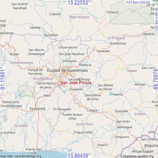
San José Pinula GPS coordinates[2]
14° 32' 45.6" North, 90° 24' 46.368" West
| Map corner | latitude | longitude |
|---|---|---|
| Upper-left | 15.22552°, | -91.11601° |
| Center: | 14.546°, | -90.41288° |
| Lower-right: | 13.86438°, | -89.70976° |
| Map W x H: | 151.3×151.3 km | = 94×94mi |
| max Lat: | 17.06606° ⇑77% North |
| San José Pinula: | 14.546° |
| min Lat: | ⇓23% South 13.9274° |
| min Long | San José Pinul | max Long |
| -92.19298° | -90.41288° | -88.59444° |
| W 69.3%⇐ | ⇒30.7% E |
Elevation
Elevation of San José Pinula is 1778 m = 5833 ft, and this is 511 m = 1677 ft above average elevation for this country.
| Max E: |
3254 m = 10676 ft | 30.4% |
| San José Pinula | 1778 m 5833 ft | |
| Avg. | 1267 m = 4157 ft | |
Min E: |
1 m = 3 ft | 69.6% |
See also: San José Pinula elevation on elevation.city.
Geographical zone
San José Pinula is located in North Torrid zone (between Equator and Tropic of Cancer). Distance of this Northern Tropic circle is 988.6 km =614.3 mi to North.| Distance of | km | miles | from San José Pinula |
|---|---|---|---|
| North Pole | 8389.7 | 5213.1 | to North |
| Arctic Circle | 5783.8 | 3593.9 | to North |
| Tropic Cancer | 988.6 | 614.3 | to North |
| Equator | 1617.4 | 1005 | to South |


Nearby cities:
15 places around San José Pinula: (largest is in red/bold)
• Casillas
23.1 km =14.4 mi,  127°
127°
• Chinautla
19.8 km =12.3 mi,  331°
331°
• Fraijanes
9.5 km =5.9 mi,  198°
198°
• Guatemala City
15.1 km =9.4 mi,  314°
314°
• Mataquescuintla
24.7 km =15.3 mi,  94°
94°
• Mixco
22.9 km =14.2 mi,  294°
294°
• Nueva Santa Rosa
23.5 km =14.6 mi,  141°
141°
• Palencia
14.7 km =9.1 mi,  23°
23°
• Petapa
16.8 km =10.4 mi,  253°
253°
• San José del Golfo
24.6 km =15.3 mi,  10°
10°
• Santa Catarina Pinula
9.7 km =6 mi, 286°
• Santa Cruz Naranjo
18.2 km =11.3 mi,  165°
165°
• Santa Rosa de Lima
21.6 km =13.4 mi, 144°
• Villa Canales
14.8 km =9.2 mi,  241°
241°
• Villa Nueva
18.7 km =11.6 mi,  262°
262°
Sources, notices
• [Note1] Compared only with cities in Guatemala existing in our database
• [Src1] Map data: © OpenStreetMap contributors (CC-BY-SA)
• [Src2] Other city data from geonames.org with taken over terms of usage.
• [Src3] Geographical zone / Annual Mean Temperature by Robert A. Rohde @ Wikipedia
