Pachalum geodata
Pachalum (Quiché) is a seat of a second-order administrative division; located in Guatemala in America/Guatemala (GMT-6) time zone. With population of 2,344 people, there are 267 cities with bigger population in this country. Compared to other cities in Guatemala, 59.9% of cities are located further ↓South; 61.4% of cities are located further ←West and 51.6% of cities have higher elevation than Pachalum. Note1


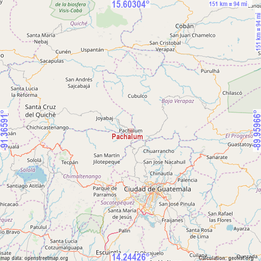
Pachalum GPS coordinates[2]
14° 55' 28.992" North, 90° 39' 46.008" West
| Map corner | latitude | longitude |
|---|---|---|
| Upper-left | 15.60304°, | -91.36591° |
| Center: | 14.92472°, | -90.66278° |
| Lower-right: | 14.24426°, | -89.95966° |
| Map W x H: | 151.1×151.1 km | = 93.9×93.9mi |
| max Lat: | 17.06606° ⇑40.1% North |
| Pachalum: | 14.92472° |
| min Lat: | ⇓59.9% South 13.9274° |
| min Long | Pachalum | max Long |
| -92.19298° | -90.66278° | -88.59444° |
| W 61.4%⇐ | ⇒38.6% E |
Elevation
Elevation of Pachalum is 1227 m = 4026 ft, and this is 40 m = 131 ft below average elevation for this country.
| Max E: |
3254 m = 10676 ft | 51.6% |
| Avg. | 1267 m = 4157 ft | |
| Pachalum | 1227 m = 4026 ft | |
Min E: |
1 m = 3 ft | 48.4% |
See also: Guatemala elevation on elevation.city.
Geographical zone
Pachalum is located in North Torrid zone (between Equator and Tropic of Cancer). Distance of this Northern Tropic circle is 946.4 km =588.1 mi to North.| Distance of | km | miles | from Pachalum |
|---|---|---|---|
| North Pole | 8347.6 | 5187 | to North |
| Arctic Circle | 5741.7 | 3567.7 | to North |
| Tropic Cancer | 946.4 | 588.1 | to North |
| Equator | 1659.5 | 1031.2 | to South |


Nearby cities:
15 places around Pachalum: (largest is in red/bold)
• Chinautla
30.3 km =18.8 mi,  144°
144°
• Chuarrancho
19.8 km =12.3 mi,  126°
126°
• Cubulco
20.3 km =12.6 mi,  10°
10°
• El Chol
19.2 km =11.9 mi,  78°
78°
• Granados
15.1 km =9.4 mi,  93°
93°
• Joyabaj
16.7 km =10.4 mi,  297°
297°
• Rabinal
25.6 km =15.9 mi,  45°
45°
• San José Poaquil
29.3 km =18.2 mi,  246°
246°
• San Juan Sacatepéquez
23 km =14.3 mi,  175°
175°
• San Martín Jilotepeque
21.3 km =13.2 mi,  220°
220°
• San Pedro Ayampuc
27.7 km =17.2 mi, 125°
• San Pedro Sacatepéquez
26.6 km =16.5 mi, 175°
• San Raimundo
19.2 km =11.9 mi,  157°
157°
• Santo Domingo Xenacoj
27.4 km =17 mi,  188°
188°
• Zacualpa
25.8 km =16 mi, 296°
Sources, notices
• [Note1] Compared only with cities in Guatemala existing in our database
• [Src1] Map data: © OpenStreetMap contributors (CC-BY-SA)
• [Src2] Other city data from geonames.org with taken over terms of usage.
• [Src3] Geographical zone / Annual Mean Temperature by Robert A. Rohde @ Wikipedia
