Toyós geodata
Toyós (Yoro) is a populated place; located in Honduras in America/Tegucigalpa (GMT-6) time zone. With population of 2,530 people, there are 135 cities with bigger population in this country. Compared to other cities in Honduras, 86.4% of cities are located further ↓South; 51% of cities are located further →East and 81.6% of cities have higher elevation than Toyós. Note1


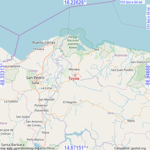
Toyós GPS coordinates[2]
15° 33' 0" North, 87° 39' 0" West
| Map corner | latitude | longitude |
|---|---|---|
| Upper-left | 16.22626°, | -88.35313° |
| Center: | 15.55°, | -87.65° |
| Lower-right: | 14.87151°, | -86.94688° |
| Map W x H: | 150.6×150.6 km | = 93.6×93.6mi |
| max Lat: | 16.45° ⇑13.6% North |
| Toyós: | 15.55° |
| min Lat: | ⇓86.4% South 13.11667° |
| min Long | Toyós | max Long |
| -89.23333° | -87.65° | -83.23333° |
| W 49%⇐ | ⇒51% E |
Elevation
Elevation of Toyós is 61 m = 200 ft, and this is 500.2 m = 1641 ft below average elevation for this country.
| Max E: |
1811 m = 5942 ft | 81.6% |
| Avg. | 561.2 m = 1841 ft | |
| Toyós | 61 m = 200 ft | |
Min E: |
1 m = 3 ft | 18.4% |
See also: Honduras elevation on elevation.city.
Geographical zone
Toyós is located in North Torrid zone (between Equator and Tropic of Cancer). Distance of this Northern Tropic circle is 876.9 km =544.9 mi to North.| Distance of | km | miles | from Toyós |
|---|---|---|---|
| North Pole | 8278.1 | 5143.8 | to North |
| Arctic Circle | 5672.2 | 3524.5 | to North |
| Tropic Cancer | 876.9 | 544.9 | to North |
| Equator | 1729 | 1074.4 | to South |


Nearby cities:
15 places around Toyós: (largest is in red/bold)
• El Negrito
26.5 km =16.5 mi,  191°
191°
• El Progreso
23.2 km =14.4 mi,  223°
223°
• Guaimitas
9.1 km =5.7 mi,  232°
232°
• La Huesa
25.3 km =15.7 mi,  278°
278°
• Matarras
27 km =16.8 mi,  97°
97°
• Mezapa
3.7 km =2.3 mi,  0°
0°
• Mezapa
28.6 km =17.8 mi,  90°
90°
• Monterrey
25.3 km =15.7 mi, 278°
• Morazán
26.5 km =16.5 mi,  168°
168°
• Nueva Florida
18.6 km =11.6 mi,  119°
119°
• Ocote Paulino
15.8 km =9.8 mi,  160°
160°
• Quebrada de Yoro
19.3 km =12 mi, 227°
• San José del Boquerón
24.4 km =15.2 mi,  252°
252°
• Tornabé
24.7 km =15.3 mi,  25°
25°
• Victoria
19.6 km =12.2 mi, 254°
Sources, notices
• [Note1] Compared only with cities in Honduras existing in our database
• [Src1] Map data: © OpenStreetMap contributors (CC-BY-SA)
• [Src2] Other city data from geonames.org with taken over terms of usage.
• [Src3] Geographical zone / Annual Mean Temperature by Robert A. Rohde @ Wikipedia
