Guaimitas geodata
Guaimitas (Yoro) is a populated place; located in Honduras in America/Tegucigalpa (GMT-6) time zone. With population of 2,321 people, there are 154 cities with bigger population in this country. Compared to other cities in Honduras, 84.6% of cities are located further ↓South; 53.8% of cities are located further →East and 84.8% of cities have higher elevation than Guaimitas. Note1


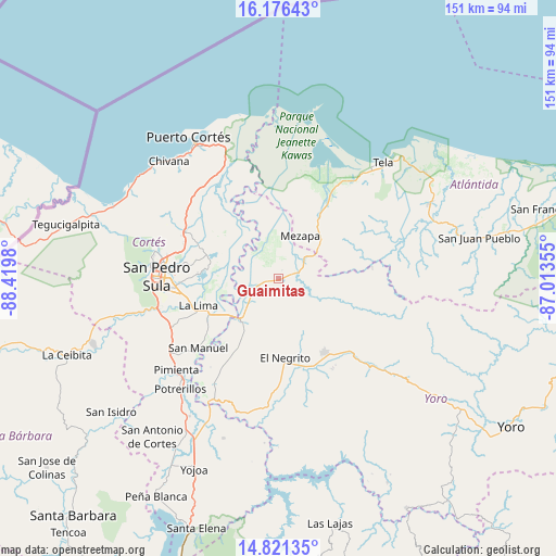
Guaimitas GPS coordinates[2]
15° 30' 0" North, 87° 43' 0.012" West
| Map corner | latitude | longitude |
|---|---|---|
| Upper-left | 16.17643°, | -88.4198° |
| Center: | 15.5°, | -87.71667° |
| Lower-right: | 14.82135°, | -87.01355° |
| Map W x H: | 150.7×150.7 km | = 93.6×93.6mi |
| max Lat: | 16.45° ⇑15.4% North |
| Guaimitas: | 15.5° |
| min Lat: | ⇓84.6% South 13.11667° |
| min Long | Guaimitas | max Long |
| -89.23333° | -87.71667° | -83.23333° |
| W 46.2%⇐ | ⇒53.8% E |
Elevation
Elevation of Guaimitas is 47 m = 154 ft, and this is 514.2 m = 1687 ft below average elevation for this country.
| Max E: |
1811 m = 5942 ft | 84.8% |
| Avg. | 561.2 m = 1841 ft | |
| Guaimitas | 47 m = 154 ft | |
Min E: |
1 m = 3 ft | 15.2% |
See also: Honduras elevation on elevation.city.
Geographical zone
Guaimitas is located in North Torrid zone (between Equator and Tropic of Cancer). Distance of this Northern Tropic circle is 882.5 km =548.4 mi to North.| Distance of | km | miles | from Guaimitas |
|---|---|---|---|
| North Pole | 8283.6 | 5147.2 | to North |
| Arctic Circle | 5677.7 | 3528 | to North |
| Tropic Cancer | 882.5 | 548.4 | to North |
| Equator | 1723.4 | 1070.9 | to South |


Nearby cities:
15 places around Guaimitas: (largest is in red/bold)
• El Negrito
20.5 km =12.7 mi,  174°
174°
• El Portillo de González
27.1 km =16.8 mi,  152°
152°
• El Progreso
14.3 km =8.9 mi,  218°
218°
• La Huesa
20.1 km =12.5 mi,  297°
297°
• La Lima
22.7 km =14.1 mi,  250°
250°
• La Mina
23.9 km =14.9 mi,  211°
211°
• Mezapa
11.7 km =7.3 mi,  37°
37°
• Monterrey
20.1 km =12.5 mi, 297°
• Morazán
23.9 km =14.9 mi, 148°
• Nueva Florida
23.5 km =14.6 mi,  99°
99°
• Ocote Paulino
15.6 km =9.7 mi,  126°
126°
• Quebrada de Yoro
10.3 km =6.4 mi, 223°
• San José del Boquerón
16.2 km =10.1 mi,  263°
263°
• Toyós
9.1 km =5.7 mi,  52°
52°
• Victoria
11.7 km =7.3 mi,  272°
272°
Sources, notices
• [Note1] Compared only with cities in Honduras existing in our database
• [Src1] Map data: © OpenStreetMap contributors (CC-BY-SA)
• [Src2] Other city data from geonames.org with taken over terms of usage.
• [Src3] Geographical zone / Annual Mean Temperature by Robert A. Rohde @ Wikipedia
