Subirana geodata
Subirana (Yoro) is a populated place; located in Honduras in America/Tegucigalpa (GMT-6) time zone. With population of 1,362 people, there are 272 cities with bigger population in this country. Compared to other cities in Honduras, 68.2% of cities are located further ↓South; 56% of cities are located further ←West and 75% of cities have lower elevation than Subirana. Note1


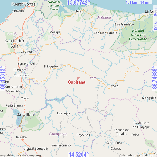
Subirana GPS coordinates[2]
15° 12' 0" North, 87° 27' 0" West
| Map corner | latitude | longitude |
|---|---|---|
| Upper-left | 15.87742°, | -88.15313° |
| Center: | 15.2°, | -87.45° |
| Lower-right: | 14.5204°, | -86.74688° |
| Map W x H: | 150.9×150.9 km | = 93.8×93.8mi |
| max Lat: | 16.45° ⇑31.8% North |
| Subirana: | 15.2° |
| min Lat: | ⇓68.2% South 13.11667° |
| min Long | Subirana | max Long |
| -89.23333° | -87.45° | -83.23333° |
| W 56%⇐ | ⇒44% E |
Elevation
Elevation of Subirana is 837 m = 2746 ft, and this is 275.8 m = 905 ft above average elevation for this country.
| Max E: |
1811 m = 5942 ft | 25% |
| Subirana | 837 m 2746 ft | |
| Avg. | 561.2 m = 1841 ft | |
Min E: |
1 m = 3 ft | 75% |
See also: Honduras elevation on elevation.city.
Geographical zone
Subirana is located in North Torrid zone (between Equator and Tropic of Cancer). Distance of this Northern Tropic circle is 915.8 km =569.1 mi to North.| Distance of | km | miles | from Subirana |
|---|---|---|---|
| North Pole | 8317 | 5167.9 | to North |
| Arctic Circle | 5711.1 | 3548.7 | to North |
| Tropic Cancer | 915.8 | 569.1 | to North |
| Equator | 1690.1 | 1050.2 | to South |


Nearby cities:
15 places around Subirana: (largest is in red/bold)
• El Bálsamo
14.9 km =9.3 mi,  186°
186°
• El Negrito
29.8 km =18.5 mi,  295°
295°
• El Portillo de González
18.6 km =11.6 mi, 299°
• La Estancia
14.2 km =8.8 mi,  310°
310°
• La Trinidad
29 km =18 mi,  112°
112°
• Las Vegas
20.4 km =12.7 mi,  180°
180°
• Lomitas
27.4 km =17 mi, 113°
• Mojimán
17.7 km =11 mi,  294°
294°
• Morazán
20.7 km =12.9 mi, 308°
• Nueva Esperanza
17.7 km =11 mi, 294°
• Ocote Paulino
29 km =18 mi,  326°
326°
• Paujiles
15.5 km =9.6 mi,  136°
136°
• Punta Ocote
17.9 km =11.1 mi,  90°
90°
• Santa Rita
18.3 km =11.4 mi,  101°
101°
• Yorito
23.2 km =14.4 mi,  129°
129°
Sources, notices
• [Note1] Compared only with cities in Honduras existing in our database
• [Src1] Map data: © OpenStreetMap contributors (CC-BY-SA)
• [Src2] Other city data from geonames.org with taken over terms of usage.
• [Src3] Geographical zone / Annual Mean Temperature by Robert A. Rohde @ Wikipedia
