El Bálsamo geodata
El Bálsamo (Yoro) is a populated place; located in Honduras in America/Tegucigalpa (GMT-6) time zone. With population of 1,741 people, there are 210 cities with bigger population in this country. Compared to other cities in Honduras, 62.2% of cities are located further ↓South; 55.2% of cities are located further ←West and 74.6% of cities have lower elevation than El Bálsamo. Note1


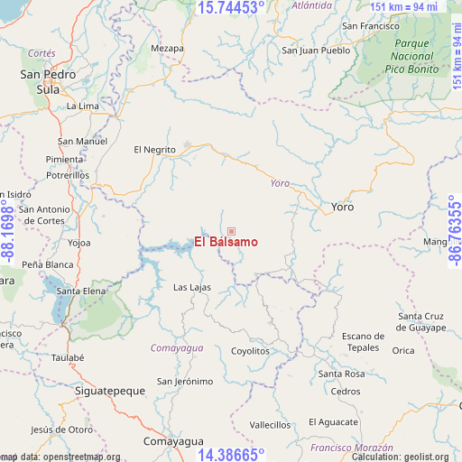
El Bálsamo GPS coordinates[2]
15° 4' 0.012" North, 87° 28' 0.012" West
| Map corner | latitude | longitude |
|---|---|---|
| Upper-left | 15.74453°, | -88.1698° |
| Center: | 15.06667°, | -87.46667° |
| Lower-right: | 14.38665°, | -86.76355° |
| Map W x H: | 151×151 km | = 93.8×93.8mi |
| max Lat: | 16.45° ⇑37.8% North |
| El Bálsamo: | 15.06667° |
| min Lat: | ⇓62.2% South 13.11667° |
| min Long | El Bálsamo | max Long |
| -89.23333° | -87.46667° | -83.23333° |
| W 55.2%⇐ | ⇒44.8% E |
Elevation
Elevation of El Bálsamo is 828 m = 2717 ft, and this is 266.8 m = 875 ft above average elevation for this country.
| Max E: |
1811 m = 5942 ft | 25.4% |
| El Bálsamo | 828 m 2717 ft | |
| Avg. | 561.2 m = 1841 ft | |
Min E: |
1 m = 3 ft | 74.6% |
See also: Honduras elevation on elevation.city.
Geographical zone
El Bálsamo is located in North Torrid zone (between Equator and Tropic of Cancer). Distance of this Northern Tropic circle is 930.7 km =578.3 mi to North.| Distance of | km | miles | from El Bálsamo |
|---|---|---|---|
| North Pole | 8331.8 | 5177.1 | to North |
| Arctic Circle | 5725.9 | 3557.9 | to North |
| Tropic Cancer | 930.7 | 578.3 | to North |
| Equator | 1675.3 | 1041 | to South |


Nearby cities:
15 places around El Bálsamo: (largest is in red/bold)
• Ayapa
31.7 km =19.7 mi,  80°
80°
• El Portillo de González
28 km =17.4 mi,  329°
329°
• La Estancia
25.7 km =16 mi,  339°
339°
• La Trinidad
28.9 km =18 mi, 82°
• Las Vegas
5.8 km =3.6 mi,  162°
162°
• Lomitas
27.1 km =16.8 mi, 82°
• Mojimán
26.4 km =16.4 mi, 327°
• Morazán
31.3 km =19.4 mi, 332°
• Nueva Esperanza
26.4 km =16.4 mi, 327°
• Paujiles
13.1 km =8.1 mi,  73°
73°
• Punta Ocote
24.6 km =15.3 mi,  53°
53°
• Santa Rita
22.6 km =14 mi,  60°
60°
• Subirana
14.9 km =9.3 mi,  6°
6°
• Sulaco
27.2 km =16.9 mi,  127°
127°
• Yorito
19.7 km =12.2 mi,  90°
90°
Sources, notices
• [Note1] Compared only with cities in Honduras existing in our database
• [Src1] Map data: © OpenStreetMap contributors (CC-BY-SA)
• [Src2] Other city data from geonames.org with taken over terms of usage.
• [Src3] Geographical zone / Annual Mean Temperature by Robert A. Rohde @ Wikipedia
