El Portillo de González geodata
El Portillo de González (Yoro) is a populated place; located in Honduras in America/Tegucigalpa (GMT-6) time zone. With population of 958 people, there are 442 cities with bigger population in this country. Compared to other cities in Honduras, 72% of cities are located further ↓South; 51.2% of cities are located further ←West and 73.4% of cities have higher elevation than El Portillo de González. Note1
Current local time in El Portillo de González:
07:29 PM, SundayDifference from your time zone: hours


El Portillo de González GPS coordinates[2]
15° 16' 59.988" North, 87° 36' 0" West
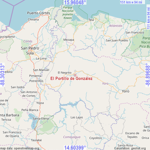
| Map corner | latitude | longitude |
|---|---|---|
| Upper-left | 15.96048°, | -88.30313° |
| Center: | 15.28333°, | -87.6° |
| Lower-right: | 14.60399°, | -86.89688° |
| Map W x H: | 150.8×150.8 km | = 93.7×93.7mi |
| max Lat: | 16.45° ⇑28% North |
| El Portillo de González: | 15.28333° |
| min Lat: | ⇓72% South 13.11667° |
| min Long | El Portillo de | max Long |
| -89.23333° | -87.6° | -83.23333° |
| W 51.2%⇐ | ⇒48.8% E |
Elevation
Elevation of El Portillo de González is 177 m = 581 ft, and this is 384.2 m = 1260 ft below average elevation for this country.
| Max E: |
1811 m = 5942 ft | 73.4% |
| Avg. | 561.2 m = 1841 ft | |
| El Portillo de González | 177 m = 581 ft | |
Min E: |
1 m = 3 ft | 26.6% |
See also: Honduras elevation on elevation.city.
Geographical zone
El Portillo de González is located in North Torrid zone (between Equator and Tropic of Cancer). Distance of this Northern Tropic circle is 906.6 km =563.3 mi to North.| Distance of | km | miles | from El Portillo de González |
|---|---|---|---|
| North Pole | 8307.7 | 5162.2 | to North |
| Arctic Circle | 5701.8 | 3542.9 | to North |
| Tropic Cancer | 906.6 | 563.3 | to North |
| Equator | 1699.3 | 1055.9 | to South |


Nearby cities:
15 places around El Portillo de González: (largest is in red/bold)
• El Bálsamo
28 km =17.4 mi,  149°
149°
• El Negrito
11.3 km =7 mi,  289°
289°
• El Progreso
25.1 km =15.6 mi,  301°
301°
• Guaimitas
27.1 km =16.8 mi,  332°
332°
• La Estancia
5.4 km =3.4 mi,  90°
90°
• La Guacamaya
21.8 km =13.5 mi,  260°
260°
• La Mina
25.3 km =15.7 mi,  278°
278°
• La Sarrosa
25.6 km =15.9 mi, 257°
• Mojimán
1.9 km =1.2 mi,  180°
180°
• Morazán
3.7 km =2.3 mi,  0°
0°
• Nueva Esperanza
1.9 km =1.2 mi, 180°
• Nueva Florida
23 km =14.3 mi,  27°
27°
• Ocote Paulino
14.8 km =9.2 mi, 0°
• Quebrada de Yoro
25.8 km =16 mi,  310°
310°
• Subirana
18.6 km =11.6 mi,  119°
119°
Sources, notices
• [Note1] Compared only with cities in Honduras existing in our database
• [Src1] Map data: © OpenStreetMap contributors (CC-BY-SA)
• [Src2] Other city data from geonames.org with taken over terms of usage.
• [Src3] Geographical zone / Annual Mean Temperature by Robert A. Rohde @ Wikipedia
