La Estancia geodata
La Estancia (Yoro) is a populated place; located in Honduras in America/Tegucigalpa (GMT-6) time zone. With population of 1,668 people, there are 222 cities with bigger population in this country. Compared to other cities in Honduras, 72% of cities are located further ↓South; 53.4% of cities are located further ←West and 71% of cities have lower elevation than La Estancia. Note1


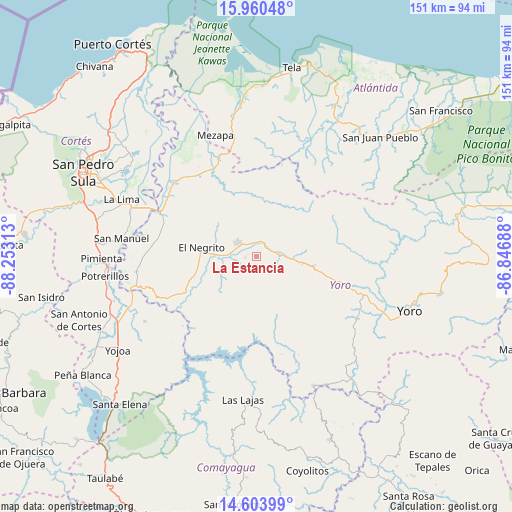
La Estancia GPS coordinates[2]
15° 16' 59.988" North, 87° 33' 0" West
| Map corner | latitude | longitude |
|---|---|---|
| Upper-left | 15.96048°, | -88.25313° |
| Center: | 15.28333°, | -87.55° |
| Lower-right: | 14.60399°, | -86.84688° |
| Map W x H: | 150.8×150.8 km | = 93.7×93.7mi |
| max Lat: | 16.45° ⇑28% North |
| La Estancia: | 15.28333° |
| min Lat: | ⇓72% South 13.11667° |
| min Long | La Estancia | max Long |
| -89.23333° | -87.55° | -83.23333° |
| W 53.4%⇐ | ⇒46.6% E |
Elevation
Elevation of La Estancia is 778 m = 2552 ft, and this is 216.8 m = 711 ft above average elevation for this country.
| Max E: |
1811 m = 5942 ft | 29% |
| La Estancia | 778 m 2552 ft | |
| Avg. | 561.2 m = 1841 ft | |
Min E: |
1 m = 3 ft | 71% |
See also: Honduras elevation on elevation.city.
Geographical zone
La Estancia is located in North Torrid zone (between Equator and Tropic of Cancer). Distance of this Northern Tropic circle is 906.6 km =563.3 mi to North.| Distance of | km | miles | from La Estancia |
|---|---|---|---|
| North Pole | 8307.7 | 5162.2 | to North |
| Arctic Circle | 5701.8 | 3542.9 | to North |
| Tropic Cancer | 906.6 | 563.3 | to North |
| Equator | 1699.3 | 1055.9 | to South |


Nearby cities:
15 places around La Estancia: (largest is in red/bold)
• El Bálsamo
25.7 km =16 mi,  159°
159°
• El Negrito
16.5 km =10.3 mi,  282°
282°
• El Portillo de González
5.4 km =3.4 mi,  270°
270°
• El Progreso
29.8 km =18.5 mi,  295°
295°
• Guaimitas
30 km =18.6 mi,  323°
323°
• La Guacamaya
27.1 km =16.8 mi,  262°
262°
• Mojimán
5.7 km =3.5 mi,  250°
250°
• Morazán
6.5 km =4 mi, 304°
• Nueva Esperanza
5.7 km =3.5 mi, 250°
• Nueva Florida
21.1 km =13.1 mi,  14°
14°
• Ocote Paulino
15.8 km =9.8 mi,  340°
340°
• Paujiles
29.6 km =18.4 mi,  133°
133°
• Punta Ocote
30.1 km =18.7 mi,  107°
107°
• Quebrada de Yoro
30.1 km =18.7 mi, 303°
• Subirana
14.2 km =8.8 mi, 130°
Sources, notices
• [Note1] Compared only with cities in Honduras existing in our database
• [Src1] Map data: © OpenStreetMap contributors (CC-BY-SA)
• [Src2] Other city data from geonames.org with taken over terms of usage.
• [Src3] Geographical zone / Annual Mean Temperature by Robert A. Rohde @ Wikipedia
