Lomitas geodata
Lomitas (Yoro) is a populated place; located in Honduras in America/Tegucigalpa (GMT-6) time zone. With population of 1,552 people, there are 231 cities with bigger population in this country. Compared to other cities in Honduras, 64% of cities are located further ↓South; 65.4% of cities are located further ←West and 53.8% of cities have lower elevation than Lomitas. Note1


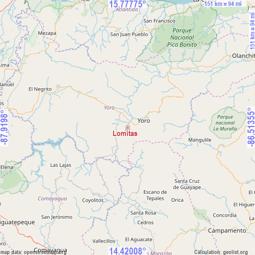
Lomitas GPS coordinates[2]
15° 6' 0" North, 87° 13' 0.012" West
| Map corner | latitude | longitude |
|---|---|---|
| Upper-left | 15.77775°, | -87.9198° |
| Center: | 15.1°, | -87.21667° |
| Lower-right: | 14.42008°, | -86.51355° |
| Map W x H: | 151×151 km | = 93.8×93.8mi |
| max Lat: | 16.45° ⇑36% North |
| Lomitas: | 15.1° |
| min Lat: | ⇓64% South 13.11667° |
| min Long | Lomitas | max Long |
| -89.23333° | -87.21667° | -83.23333° |
| W 65.4%⇐ | ⇒34.6% E |
Elevation
Elevation of Lomitas is 613 m = 2011 ft, and this is 51.8 m = 170 ft above average elevation for this country.
| Max E: |
1811 m = 5942 ft | 46.2% |
| Lomitas | 613 m 2011 ft | |
| Avg. | 561.2 m = 1841 ft | |
Min E: |
1 m = 3 ft | 53.8% |
See also: Honduras elevation on elevation.city.
Geographical zone
Lomitas is located in North Torrid zone (between Equator and Tropic of Cancer). Distance of this Northern Tropic circle is 927 km =576 mi to North.| Distance of | km | miles | from Lomitas |
|---|---|---|---|
| North Pole | 8328.1 | 5174.8 | to North |
| Arctic Circle | 5722.2 | 3555.6 | to North |
| Tropic Cancer | 927 | 576 | to North |
| Equator | 1679 | 1043.3 | to South |


Nearby cities:
15 places around Lomitas: (largest is in red/bold)
• Ayapa
4.6 km =2.9 mi,  73°
73°
• El Bálsamo
27.1 km =16.8 mi,  262°
262°
• La Trinidad
1.8 km =1.1 mi,  90°
90°
• Las Vegas
26.7 km =16.6 mi,  249°
249°
• Marale
25.1 km =15.6 mi,  163°
163°
• Paujiles
14.3 km =8.9 mi,  270°
270°
• Punta Ocote
13.2 km =8.2 mi,  327°
327°
• San Antonio
26.9 km =16.7 mi,  15°
15°
• San José
24.7 km =15.3 mi,  12°
12°
• San José del Potrero
30.5 km =19 mi,  193°
193°
• Santa Rita
10.3 km =6.4 mi,  316°
316°
• Subirana
27.4 km =17 mi,  293°
293°
• Sulaco
21.1 km =13.1 mi, 194°
• Yorito
8.1 km =5 mi,  242°
242°
• Yoro
10.4 km =6.5 mi, 66°
Sources, notices
• [Note1] Compared only with cities in Honduras existing in our database
• [Src1] Map data: © OpenStreetMap contributors (CC-BY-SA)
• [Src2] Other city data from geonames.org with taken over terms of usage.
• [Src3] Geographical zone / Annual Mean Temperature by Robert A. Rohde @ Wikipedia
