Las Vegas geodata
Las Vegas (Yoro) is a populated place; located in Honduras in America/Tegucigalpa (GMT-6) time zone. With population of 1,308 people, there are 288 cities with bigger population in this country. Compared to other cities in Honduras, 57.8% of cities are located further ↓South; 56% of cities are located further ←West and 53.4% of cities have higher elevation than Las Vegas. Note1


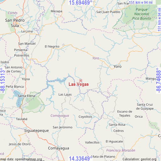
Las Vegas GPS coordinates[2]
15° 1' 0.012" North, 87° 27' 0" West
| Map corner | latitude | longitude |
|---|---|---|
| Upper-left | 15.69469°, | -88.15313° |
| Center: | 15.01667°, | -87.45° |
| Lower-right: | 14.33649°, | -86.74688° |
| Map W x H: | 151×151 km | = 93.8×93.8mi |
| max Lat: | 16.45° ⇑42.2% North |
| Las Vegas: | 15.01667° |
| min Lat: | ⇓57.8% South 13.11667° |
| min Long | Las Vegas | max Long |
| -89.23333° | -87.45° | -83.23333° |
| W 56%⇐ | ⇒44% E |
Elevation
Elevation of Las Vegas is 512 m = 1680 ft, and this is 49.2 m = 161 ft below average elevation for this country.
| Max E: |
1811 m = 5942 ft | 53.4% |
| Avg. | 561.2 m = 1841 ft | |
| Las Vegas | 512 m = 1680 ft | |
Min E: |
1 m = 3 ft | 46.6% |
See also: Honduras elevation on elevation.city.
Geographical zone
Las Vegas is located in North Torrid zone (between Equator and Tropic of Cancer). Distance of this Northern Tropic circle is 936.2 km =581.7 mi to North.| Distance of | km | miles | from Las Vegas |
|---|---|---|---|
| North Pole | 8337.4 | 5180.6 | to North |
| Arctic Circle | 5731.5 | 3561.4 | to North |
| Tropic Cancer | 936.2 | 581.7 | to North |
| Equator | 1669.7 | 1037.5 | to South |


Nearby cities:
15 places around Las Vegas: (largest is in red/bold)
• Ayapa
31.3 km =19.4 mi,  70°
70°
• El Bálsamo
5.8 km =3.6 mi,  342°
342°
• La Estancia
31.5 km =19.6 mi, 340°
• La Trinidad
28.4 km =17.6 mi, 70°
• Lomitas
26.7 km =16.6 mi, 69°
• Minas de Oro
26.4 km =16.4 mi,  155°
155°
• Nueva Esperanza
32.1 km =19.9 mi,  329°
329°
• Paujiles
14.2 km =8.8 mi,  49°
49°
• Punta Ocote
27.1 km =16.8 mi,  41°
41°
• San José del Potrero
27.1 km =16.8 mi,  138°
138°
• San Luis
29.9 km =18.6 mi,  173°
173°
• Santa Rita
24.5 km =15.2 mi, 47°
• Subirana
20.4 km =12.7 mi,  0°
0°
• Sulaco
22.6 km =14 mi,  119°
119°
• Yorito
18.7 km =11.6 mi, 72°
Sources, notices
• [Note1] Compared only with cities in Honduras existing in our database
• [Src1] Map data: © OpenStreetMap contributors (CC-BY-SA)
• [Src2] Other city data from geonames.org with taken over terms of usage.
• [Src3] Geographical zone / Annual Mean Temperature by Robert A. Rohde @ Wikipedia
