Punta Ocote geodata
Punta Ocote (Yoro) is a populated place; located in Honduras in America/Tegucigalpa (GMT-6) time zone. With population of 1,399 people, there are 267 cities with bigger population in this country. Compared to other cities in Honduras, 68.2% of cities are located further ↓South; 62.2% of cities are located further ←West and 61.6% of cities have lower elevation than Punta Ocote. Note1


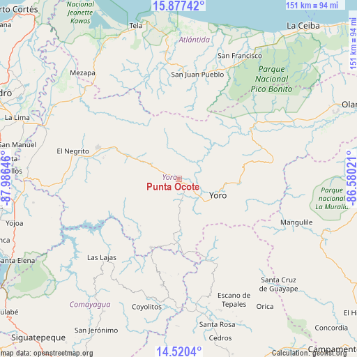
Punta Ocote GPS coordinates[2]
15° 12' 0" North, 87° 16' 59.988" West
| Map corner | latitude | longitude |
|---|---|---|
| Upper-left | 15.87742°, | -87.98646° |
| Center: | 15.2°, | -87.28333° |
| Lower-right: | 14.5204°, | -86.58021° |
| Map W x H: | 150.9×150.9 km | = 93.8×93.8mi |
| max Lat: | 16.45° ⇑31.8% North |
| Punta Ocote: | 15.2° |
| min Lat: | ⇓68.2% South 13.11667° |
| min Long | Punta Ocote | max Long |
| -89.23333° | -87.28333° | -83.23333° |
| W 62.2%⇐ | ⇒37.8% E |
Elevation
Elevation of Punta Ocote is 692 m = 2270 ft, and this is 130.8 m = 429 ft above average elevation for this country.
| Max E: |
1811 m = 5942 ft | 38.4% |
| Punta Ocote | 692 m 2270 ft | |
| Avg. | 561.2 m = 1841 ft | |
Min E: |
1 m = 3 ft | 61.6% |
See also: Honduras elevation on elevation.city.
Geographical zone
Punta Ocote is located in North Torrid zone (between Equator and Tropic of Cancer). Distance of this Northern Tropic circle is 915.8 km =569.1 mi to North.| Distance of | km | miles | from Punta Ocote |
|---|---|---|---|
| North Pole | 8317 | 5167.9 | to North |
| Arctic Circle | 5711.1 | 3548.7 | to North |
| Tropic Cancer | 915.8 | 569.1 | to North |
| Equator | 1690.1 | 1050.2 | to South |


Nearby cities:
15 places around Punta Ocote: (largest is in red/bold)
• Ayapa
15.2 km =9.4 mi,  130°
130°
• El Bálsamo
24.6 km =15.3 mi,  233°
233°
• La Estancia
30.1 km =18.7 mi,  287°
287°
• La Rosa
28.6 km =17.8 mi,  54°
54°
• La Trinidad
14.3 km =8.9 mi,  141°
141°
• Las Vegas
27.1 km =16.8 mi,  221°
221°
• Lomitas
13.2 km =8.2 mi,  147°
147°
• Paujiles
13.2 km =8.2 mi,  212°
212°
• San Antonio
20.6 km =12.8 mi,  43°
43°
• San José
18 km =11.2 mi, 43°
• Santa Rita
3.7 km =2.3 mi,  180°
180°
• Subirana
17.9 km =11.1 mi,  270°
270°
• Sulaco
31.6 km =19.6 mi, 176°
• Yorito
14.8 km =9.2 mi, 180°
• Yoro
18.1 km =11.2 mi,  112°
112°
Sources, notices
• [Note1] Compared only with cities in Honduras existing in our database
• [Src1] Map data: © OpenStreetMap contributors (CC-BY-SA)
• [Src2] Other city data from geonames.org with taken over terms of usage.
• [Src3] Geographical zone / Annual Mean Temperature by Robert A. Rohde @ Wikipedia
