San Antonio geodata
San Antonio (Yoro) is a populated place; located in Honduras in America/Tegucigalpa (GMT-6) time zone. With population of 1,711 people, there are 214 cities with bigger population in this country. Compared to other cities in Honduras, 75.2% of cities are located further ↓South; 67.8% of cities are located further ←West and 50.2% of cities have lower elevation than San Antonio. Note1


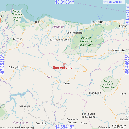
San Antonio GPS coordinates[2]
15° 19' 59.988" North, 87° 9' 0" West
| Map corner | latitude | longitude |
|---|---|---|
| Upper-left | 16.01031°, | -87.85313° |
| Center: | 15.33333°, | -87.15° |
| Lower-right: | 14.65415°, | -86.44688° |
| Map W x H: | 150.8×150.8 km | = 93.7×93.7mi |
| max Lat: | 16.45° ⇑24.8% North |
| San Antonio: | 15.33333° |
| min Lat: | ⇓75.2% South 13.11667° |
| min Long | San Antonio | max Long |
| -89.23333° | -87.15° | -83.23333° |
| W 67.8%⇐ | ⇒32.2% E |
Elevation
Elevation of San Antonio is 577 m = 1893 ft, and this is 15.8 m = 52 ft above average elevation for this country.
| Max E: |
1811 m = 5942 ft | 49.8% |
| San Antonio | 577 m 1893 ft | |
| Avg. | 561.2 m = 1841 ft | |
Min E: |
1 m = 3 ft | 50.2% |
See also: Honduras elevation on elevation.city.
Geographical zone
San Antonio is located in North Torrid zone (between Equator and Tropic of Cancer). Distance of this Northern Tropic circle is 901 km =559.9 mi to North.| Distance of | km | miles | from San Antonio |
|---|---|---|---|
| North Pole | 8302.2 | 5158.7 | to North |
| Arctic Circle | 5696.3 | 3539.5 | to North |
| Tropic Cancer | 901 | 559.9 | to North |
| Equator | 1704.9 | 1059.4 | to South |


Nearby cities:
15 places around San Antonio: (largest is in red/bold)
• Ayapa
24.8 km =15.4 mi,  186°
186°
• Jocón
20.4 km =12.7 mi,  105°
105°
• La Masica
31.7 km =19.7 mi,  6°
6°
• La Rosa
9.1 km =5.7 mi,  78°
78°
• La Trinidad
26.5 km =16.5 mi, 191°
• Lomitas
26.9 km =16.7 mi,  195°
195°
• Matarras
33.7 km =20.9 mi,  307°
307°
• Paujiles
33.7 km =20.9 mi,  219°
219°
• Punta Ocote
20.6 km =12.8 mi, 223°
• San Antonio
29.7 km =18.5 mi,  0°
0°
• San José
2.6 km =1.6 mi, 223°
• San Juan Pueblo
29.2 km =18.1 mi,  342°
342°
• Santa Rita
23.4 km =14.5 mi, 217°
• Yorito
32.9 km =20.4 mi,  205°
205°
• Yoro
21.9 km =13.6 mi,  173°
173°
Sources, notices
• [Note1] Compared only with cities in Honduras existing in our database
• [Src1] Map data: © OpenStreetMap contributors (CC-BY-SA)
• [Src2] Other city data from geonames.org with taken over terms of usage.
• [Src3] Geographical zone / Annual Mean Temperature by Robert A. Rohde @ Wikipedia
