Celldömölk geodata
Celldömölk (Vas) is a seat of a second-order administrative division; located in Hungary in Europe/Budapest (GMT+2) time zone. With population of 11,421 people, there are 145 cities with bigger population in this country. Compared to other cities in Hungary, 59.1% of cities are located further ↑North; 95.7% of cities are located further →East and 68.8% of cities have lower elevation than Celldömölk. Note1


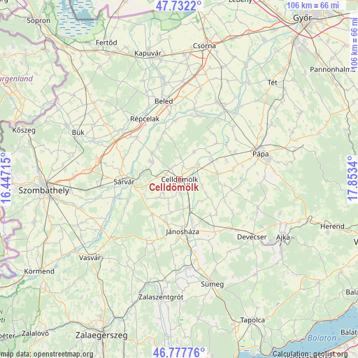
Celldömölk GPS coordinates[2]
47° 15' 25.668" North, 17° 9' 0.972" East
| Map corner | latitude | longitude |
|---|---|---|
| Upper-left | 47.7322°, | 16.44715° |
| Center: | 47.25713°, | 17.15027° |
| Lower-right: | 46.77776°, | 17.8534° |
| Map W x H: | 106.1×106.1 km | = 65.9×65.9mi |
| max Lat: | 48.46667° ⇑59.1% North |
| Celldömölk: | 47.25713° |
| min Lat: | ⇓40.9% South 45.79108° |
| min Long | Celldömölk | max Long |
| 16.27358° | 17.15027° | 22.68096° |
| W 4.3%⇐ | ⇒95.7% E |
Elevation
Elevation of Celldömölk is 136 m = 446 ft, and this is 6.3 m = 21 ft above average elevation for this country.
| Max E: |
444 m = 1457 ft | 31.2% |
| Celldömölk | 136 m 446 ft | |
| Avg. | 129.7 m = 426 ft | |
Min E: |
71 m = 233 ft | 68.8% |
See also: Hungary elevation on elevation.city.
Geographical zone
Celldömölk is located in North temperate zone (between Tropic of Cancer and the Arctic Circle). Distance of this North polar circle is 2146.7 km =1333.9 mi to North.| Distance of | km | miles | from Celldömölk |
|---|---|---|---|
| North Pole | 4752.6 | 2953.1 | to North |
| Arctic Circle | 2146.7 | 1333.9 | to North |
| Tropic Cancer | 2648.6 | 1645.8 | to South |
| Equator | 5254.5 | 3265 | to South |


Nearby cities:
15 places around Celldömölk: (largest is in red/bold)
• Alsóújlak
29.8 km =18.5 mi,  228°
228°
• Beled
23.6 km =14.7 mi,  349°
349°
• Bük
33.3 km =20.7 mi,  295°
295°
• Csabrendek
29.1 km =18.1 mi,  158°
158°
• Devecser
27.7 km =17.2 mi,  128°
128°
• Jánosháza
15.4 km =9.6 mi,  175°
175°
• Kisfalud
30.5 km =19 mi, 351°
• Mihályi
28.8 km =17.9 mi, 351°
• Pápa
25.3 km =15.7 mi,  71°
71°
• Répcelak
20.8 km =12.9 mi,  331°
331°
• Szany
25.8 km =16 mi,  26°
26°
• Sárvár
16.2 km =10.1 mi,  268°
268°
• Sümeg
32.7 km =20.3 mi, 162°
• Türje
30.6 km =19 mi,  186°
186°
• Vép
32.4 km =20.1 mi,  264°
264°
Sources, notices
• [Note1] Compared only with cities in Hungary existing in our database
• [Src1] Map data: © OpenStreetMap contributors (CC-BY-SA)
• [Src2] Other city data from geonames.org with taken over terms of usage.
• [Src3] Geographical zone / Annual Mean Temperature by Robert A. Rohde @ Wikipedia
