Jánosháza geodata
Jánosháza (Vas) is a populated place; located in Hungary in Europe/Budapest (GMT+2) time zone. With population of 2,754 people, there are 549 cities with bigger population in this country. Compared to other cities in Hungary, 64.7% of cities are located further ↑North; 95.6% of cities are located further →East and 75.8% of cities have lower elevation than Jánosháza. Note1


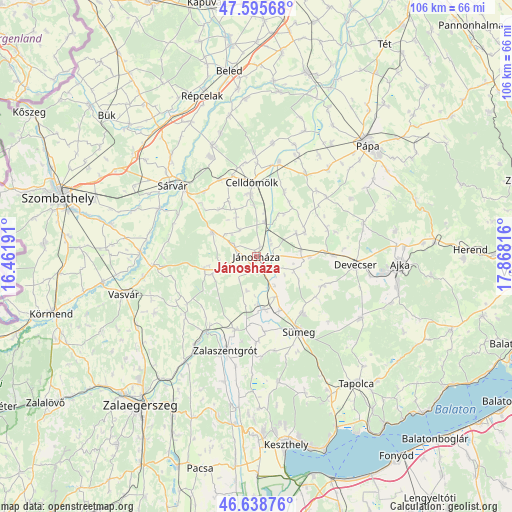
Jánosháza GPS coordinates[2]
47° 7' 9.732" North, 17° 9' 54.108" East
| Map corner | latitude | longitude |
|---|---|---|
| Upper-left | 47.59568°, | 16.46191° |
| Center: | 47.11937°, | 17.16503° |
| Lower-right: | 46.63876°, | 17.86816° |
| Map W x H: | 106.4×106.4 km | = 66.1×66.1mi |
| max Lat: | 48.46667° ⇑64.7% North |
| Jánosháza: | 47.11937° |
| min Lat: | ⇓35.3% South 45.79108° |
| min Long | Jánosháza | max Long |
| 16.27358° | 17.16503° | 22.68096° |
| W 4.4%⇐ | ⇒95.6% E |
Elevation
Elevation of Jánosháza is 148 m = 486 ft, and this is 18.3 m = 60 ft above average elevation for this country.
| Max E: |
444 m = 1457 ft | 24.2% |
| Jánosháza | 148 m 486 ft | |
| Avg. | 129.7 m = 426 ft | |
Min E: |
71 m = 233 ft | 75.8% |
See also: Hungary elevation on elevation.city.
Geographical zone
Jánosháza is located in North temperate zone (between Tropic of Cancer and the Arctic Circle). Distance of this North polar circle is 2162 km =1343.4 mi to North.| Distance of | km | miles | from Jánosháza |
|---|---|---|---|
| North Pole | 4767.9 | 2962.6 | to North |
| Arctic Circle | 2162 | 1343.4 | to North |
| Tropic Cancer | 2633.3 | 1636.3 | to South |
| Equator | 5239.2 | 3255.5 | to South |


Nearby cities:
15 places around Jánosháza: (largest is in red/bold)
• Ajka
29.9 km =18.6 mi,  93°
93°
• Alsóújlak
24 km =14.9 mi,  259°
259°
• Celldömölk
15.4 km =9.6 mi,  355°
355°
• Csabrendek
15.2 km =9.4 mi,  140°
140°
• Cserszegtomaj
35.6 km =22.1 mi,  173°
173°
• Devecser
20.7 km =12.9 mi, 94°
• Nemesbük
33.7 km =20.9 mi,  181°
181°
• Pápa
32.7 km =20.3 mi,  44°
44°
• Répcelak
35.3 km =21.9 mi,  341°
341°
• Sárvár
22.9 km =14.2 mi,  310°
310°
• Sümeg
18.1 km =11.2 mi,  150°
150°
• Tapolca
33.7 km =20.9 mi, 141°
• Türje
15.7 km =9.8 mi,  196°
196°
• Vasvár
28.7 km =17.8 mi,  254°
254°
• Zalaszentgrót
20.5 km =12.7 mi, 198°
Sources, notices
• [Note1] Compared only with cities in Hungary existing in our database
• [Src1] Map data: © OpenStreetMap contributors (CC-BY-SA)
• [Src2] Other city data from geonames.org with taken over terms of usage.
• [Src3] Geographical zone / Annual Mean Temperature by Robert A. Rohde @ Wikipedia
