Zalaszentgrót geodata
Zalaszentgrót (Zala) is a seat of a second-order administrative division; located in Hungary in Europe/Budapest (GMT+2) time zone. With population of 7,796 people, there are 201 cities with bigger population in this country. Compared to other cities in Hungary, 71.1% of cities are located further ↑North; 96.8% of cities are located further →East and 58.3% of cities have lower elevation than Zalaszentgrót. Note1


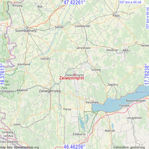
Zalaszentgrót GPS coordinates[2]
46° 56' 41.064" North, 17° 4' 45.3" East
| Map corner | latitude | longitude |
|---|---|---|
| Upper-left | 47.42261°, | 16.37613° |
| Center: | 46.94474°, | 17.07925° |
| Lower-right: | 46.46256°, | 17.78238° |
| Map W x H: | 106.7×106.7 km | = 66.3×66.3mi |
| max Lat: | 48.46667° ⇑71.1% North |
| Zalaszentgrót: | 46.94474° |
| min Lat: | ⇓28.9% South 45.79108° |
| min Long | Zalaszentgrót | max Long |
| 16.27358° | 17.07925° | 22.68096° |
| W 3.2%⇐ | ⇒96.8% E |
Elevation
Elevation of Zalaszentgrót is 124 m = 407 ft, and this is 5.7 m = 19 ft below average elevation for this country.
| Max E: |
444 m = 1457 ft | 41.7% |
| Avg. | 129.7 m = 426 ft | |
| Zalaszentgrót | 124 m = 407 ft | |
Min E: |
71 m = 233 ft | 58.3% |
See also: Hungary elevation on elevation.city.
Geographical zone
Zalaszentgrót is located in North temperate zone (between Tropic of Cancer and the Arctic Circle). Distance of this North polar circle is 2181.4 km =1355.5 mi to North.| Distance of | km | miles | from Zalaszentgrót |
|---|---|---|---|
| North Pole | 4787.3 | 2974.7 | to North |
| Arctic Circle | 2181.4 | 1355.5 | to North |
| Tropic Cancer | 2613.8 | 1624.1 | to South |
| Equator | 5219.8 | 3243.4 | to South |


Nearby cities:
15 places around Zalaszentgrót: (largest is in red/bold)
• Alsóújlak
22.8 km =14.2 mi,  311°
311°
• Csabrendek
17.8 km =11.1 mi,  64°
64°
• Cserszegtomaj
19.2 km =11.9 mi,  145°
145°
• Gyenesdiás
25 km =15.5 mi,  140°
140°
• Hévíz
18.9 km =11.7 mi,  155°
155°
• Jánosháza
20.5 km =12.7 mi,  18°
18°
• Keszthely
23.3 km =14.5 mi, 147°
• Nemesbük
15.2 km =9.4 mi, 159°
• Pacsa
25.5 km =15.8 mi,  191°
191°
• Sármellék
26.7 km =16.6 mi,  165°
165°
• Sümeg
15.8 km =9.8 mi,  76°
76°
• Türje
4.8 km =3 mi,  26°
26°
• Vasvár
24.2 km =15 mi,  298°
298°
• Vonyarcvashegy
27.3 km =17 mi, 139°
• Zalaegerszeg
21.3 km =13.2 mi,  236°
236°
Sources, notices
• [Note1] Compared only with cities in Hungary existing in our database
• [Src1] Map data: © OpenStreetMap contributors (CC-BY-SA)
• [Src2] Other city data from geonames.org with taken over terms of usage.
• [Src3] Geographical zone / Annual Mean Temperature by Robert A. Rohde @ Wikipedia
