Ócsa geodata
Ócsa (Pest) is a populated place; located in Hungary in Europe/Budapest (GMT+2) time zone. With population of 9,097 people, there are 181 cities with bigger population in this country. Compared to other cities in Hungary, 57.2% of cities are located further ↑North; 56.3% of cities are located further →East and 58.1% of cities have higher elevation than Ócsa. Note1


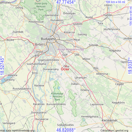
Ócsa GPS coordinates[2]
47° 17' 59.496" North, 19° 13' 50.052" East
| Map corner | latitude | longitude |
|---|---|---|
| Upper-left | 47.77454°, | 18.52745° |
| Center: | 47.29986°, | 19.23057° |
| Lower-right: | 46.82088°, | 19.9337° |
| Map W x H: | 106×106 km | = 65.9×65.9mi |
| max Lat: | 48.46667° ⇑57.2% North |
| Ócsa: | 47.29986° |
| min Lat: | ⇓42.8% South 45.79108° |
| min Long | Ócsa | max Long |
| 16.27358° | 19.23057° | 22.68096° |
| W 43.7%⇐ | ⇒56.3% E |
Elevation
Elevation of Ócsa is 111 m = 364 ft, and this is 18.7 m = 61 ft below average elevation for this country.
| Max E: |
444 m = 1457 ft | 58.1% |
| Avg. | 129.7 m = 426 ft | |
| Ócsa | 111 m = 364 ft | |
Min E: |
71 m = 233 ft | 41.9% |
See also: Hungary elevation on elevation.city.
Geographical zone
Ócsa is located in North temperate zone (between Tropic of Cancer and the Arctic Circle). Distance of this North polar circle is 2141.9 km =1330.9 mi to North.| Distance of | km | miles | from Ócsa |
|---|---|---|---|
| North Pole | 4747.8 | 2950.1 | to North |
| Arctic Circle | 2141.9 | 1330.9 | to North |
| Tropic Cancer | 2653.3 | 1648.7 | to South |
| Equator | 5259.3 | 3268 | to South |


Nearby cities:
15 places around Ócsa: (largest is in red/bold)
• Alsónémedi
5.7 km =3.5 mi,  287°
287°
• Budapest XXIII. kerület
14 km =8.7 mi,  321°
321°
• Bugyi
10.2 km =6.3 mi,  218°
218°
• Dabas
14 km =8.7 mi,  154°
154°
• Dunaharaszti
11.7 km =7.3 mi,  301°
301°
• Dunavarsány
12.6 km =7.8 mi,  259°
259°
• Délegyháza
12.4 km =7.7 mi,  238°
238°
• Felsőpakony
4.9 km =3 mi,  5°
5°
• Gyál
9.4 km =5.8 mi,  355°
355°
• Inárcs
8.4 km =5.2 mi,  120°
120°
• Kakucs
12 km =7.5 mi, 122°
• Taksony
12.8 km =8 mi, 285°
• Vecsés
12.6 km =7.8 mi,  19°
19°
• Újhartyán
14.7 km =9.1 mi,  127°
127°
• Üllő
13.6 km =8.5 mi,  43°
43°
Sources, notices
• [Note1] Compared only with cities in Hungary existing in our database
• [Src1] Map data: © OpenStreetMap contributors (CC-BY-SA)
• [Src2] Other city data from geonames.org with taken over terms of usage.
• [Src3] Geographical zone / Annual Mean Temperature by Robert A. Rohde @ Wikipedia
