Tapolca geodata
Tapolca (Veszprém) is a seat of a second-order administrative division; located in Hungary in Europe/Budapest (GMT+2) time zone. With population of 17,598 people, there are 99 cities with bigger population in this country. Compared to other cities in Hungary, 73.4% of cities are located further ↑North; 92.1% of cities are located further →East and 58.3% of cities have lower elevation than Tapolca. Note1


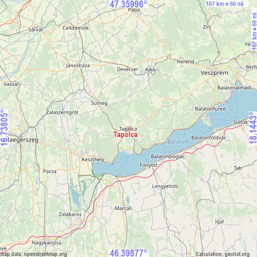
Tapolca GPS coordinates[2]
46° 52' 53.472" North, 17° 26' 28.212" East
| Map corner | latitude | longitude |
|---|---|---|
| Upper-left | 47.35996°, | 16.73805° |
| Center: | 46.88152°, | 17.44117° |
| Lower-right: | 46.39877°, | 18.1443° |
| Map W x H: | 106.9×106.9 km | = 66.4×66.4mi |
| max Lat: | 48.46667° ⇑73.4% North |
| Tapolca: | 46.88152° |
| min Lat: | ⇓26.6% South 45.79108° |
| min Long | Tapolca | max Long |
| 16.27358° | 17.44117° | 22.68096° |
| W 7.9%⇐ | ⇒92.1% E |
Elevation
Elevation of Tapolca is 124 m = 407 ft, and this is 5.7 m = 19 ft below average elevation for this country.
| Max E: |
444 m = 1457 ft | 41.7% |
| Avg. | 129.7 m = 426 ft | |
| Tapolca | 124 m = 407 ft | |
Min E: |
71 m = 233 ft | 58.3% |
See also: Hungary elevation on elevation.city.
Geographical zone
Tapolca is located in North temperate zone (between Tropic of Cancer and the Arctic Circle). Distance of this North polar circle is 2188.4 km =1359.8 mi to North.| Distance of | km | miles | from Tapolca |
|---|---|---|---|
| North Pole | 4794.3 | 2979 | to North |
| Arctic Circle | 2188.4 | 1359.8 | to North |
| Tropic Cancer | 2606.8 | 1619.8 | to South |
| Equator | 5212.7 | 3239 | to South |


Nearby cities:
15 places around Tapolca: (largest is in red/bold)
• Badacsonytomaj
10 km =6.2 mi,  146°
146°
• Balatonberény
21.5 km =13.4 mi,  205°
205°
• Balatonboglár
19.4 km =12.1 mi,  127°
127°
• Balatonfenyves
18.9 km =11.7 mi,  168°
168°
• Balatonlelle
22.2 km =13.8 mi,  119°
119°
• Csabrendek
18.6 km =11.6 mi,  322°
322°
• Cserszegtomaj
19 km =11.8 mi,  242°
242°
• Fonyód
17.5 km =10.9 mi,  143°
143°
• Gyenesdiás
17 km =10.6 mi,  223°
223°
• Hévíz
22 km =13.7 mi, 242°
• Keszthely
19.6 km =12.2 mi,  230°
230°
• Révfülöp
14.9 km =9.3 mi,  114°
114°
• Sümeg
16.1 km =10 mi,  311°
311°
• Vonyarcvashegy
17 km =10.6 mi, 215°
• Zánka
18.5 km =11.5 mi,  93°
93°
Sources, notices
• [Note1] Compared only with cities in Hungary existing in our database
• [Src1] Map data: © OpenStreetMap contributors (CC-BY-SA)
• [Src2] Other city data from geonames.org with taken over terms of usage.
• [Src3] Geographical zone / Annual Mean Temperature by Robert A. Rohde @ Wikipedia
