Sümeg geodata
Sümeg (Veszprém) is a populated place; located in Hungary in Europe/Budapest (GMT+2) time zone. With population of 6,726 people, there are 228 cities with bigger population in this country. Compared to other cities in Hungary, 70% of cities are located further ↑North; 94.4% of cities are located further →East and 89.3% of cities have lower elevation than Sümeg. Note1


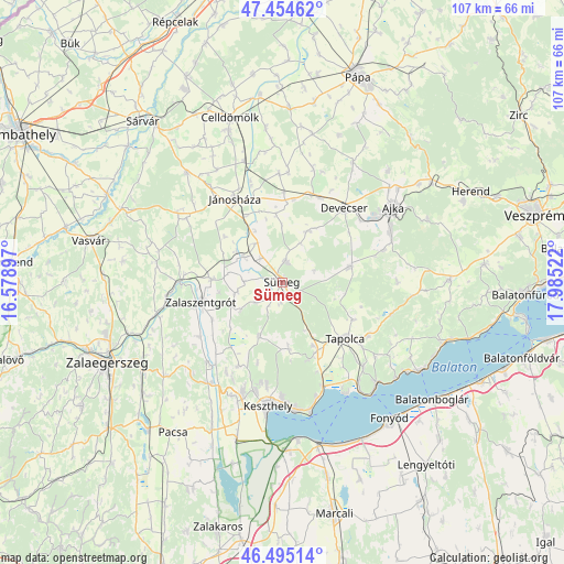
Sümeg GPS coordinates[2]
46° 58' 37.308" North, 17° 16' 55.524" East
| Map corner | latitude | longitude |
|---|---|---|
| Upper-left | 47.45462°, | 16.57897° |
| Center: | 46.97703°, | 17.28209° |
| Lower-right: | 46.49514°, | 17.98522° |
| Map W x H: | 106.7×106.7 km | = 66.3×66.3mi |
| max Lat: | 48.46667° ⇑70% North |
| Sümeg: | 46.97703° |
| min Lat: | ⇓30% South 45.79108° |
| min Long | Sümeg | max Long |
| 16.27358° | 17.28209° | 22.68096° |
| W 5.6%⇐ | ⇒94.4% E |
Elevation
Elevation of Sümeg is 185 m = 607 ft, and this is 55.3 m = 181 ft above average elevation for this country.
| Max E: |
444 m = 1457 ft | 10.7% |
| Sümeg | 185 m 607 ft | |
| Avg. | 129.7 m = 426 ft | |
Min E: |
71 m = 233 ft | 89.3% |
See also: Hungary elevation on elevation.city.
Geographical zone
Sümeg is located in North temperate zone (between Tropic of Cancer and the Arctic Circle). Distance of this North polar circle is 2177.8 km =1353.2 mi to North.| Distance of | km | miles | from Sümeg |
|---|---|---|---|
| North Pole | 4783.7 | 2972.5 | to North |
| Arctic Circle | 2177.8 | 1353.2 | to North |
| Tropic Cancer | 2617.4 | 1626.4 | to South |
| Equator | 5223.4 | 3245.7 | to South |


Nearby cities:
15 places around Sümeg: (largest is in red/bold)
• Ajka
25.2 km =15.7 mi,  56°
56°
• Badacsonytomaj
25.8 km =16 mi,  137°
137°
• Csabrendek
4.1 km =2.5 mi,  9°
9°
• Cserszegtomaj
20 km =12.4 mi,  193°
193°
• Devecser
18.3 km =11.4 mi,  40°
40°
• Gyenesdiás
23 km =14.3 mi,  179°
179°
• Hévíz
22.1 km =13.7 mi,  199°
199°
• Jánosháza
18.1 km =11.2 mi,  330°
330°
• Keszthely
23.4 km =14.5 mi, 187°
• Nemesbük
20.5 km =12.7 mi,  209°
209°
• Tapolca
16.1 km =10 mi,  131°
131°
• Türje
13.3 km =8.3 mi,  273°
273°
• Vonyarcvashegy
24.5 km =15.2 mi,  174°
174°
• Zalaszentgrót
15.8 km =9.8 mi,  256°
256°
• Úrkút
29.9 km =18.6 mi,  66°
66°
Sources, notices
• [Note1] Compared only with cities in Hungary existing in our database
• [Src1] Map data: © OpenStreetMap contributors (CC-BY-SA)
• [Src2] Other city data from geonames.org with taken over terms of usage.
• [Src3] Geographical zone / Annual Mean Temperature by Robert A. Rohde @ Wikipedia
