Vonyarcvashegy geodata
Vonyarcvashegy (Zala) is a populated place; located in Hungary in Europe/Budapest (GMT+2) time zone. With population of 1,902 people, there are 824 cities with bigger population in this country. Compared to other cities in Hungary, 78.3% of cities are located further ↑North; 94% of cities are located further →East and 54.7% of cities have higher elevation than Vonyarcvashegy. Note1


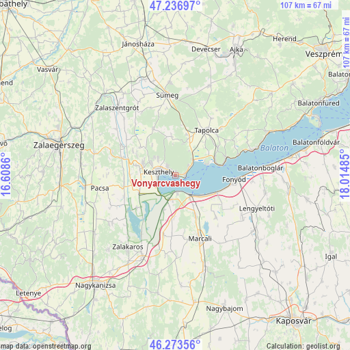
Vonyarcvashegy GPS coordinates[2]
46° 45' 26.712" North, 17° 18' 42.192" East
| Map corner | latitude | longitude |
|---|---|---|
| Upper-left | 47.23697°, | 16.6086° |
| Center: | 46.75742°, | 17.31172° |
| Lower-right: | 46.27356°, | 18.01485° |
| Map W x H: | 107.1×107.1 km | = 66.5×66.5mi |
| max Lat: | 48.46667° ⇑78.3% North |
| Vonyarcvashegy: | 46.75742° |
| min Lat: | ⇓21.7% South 45.79108° |
| min Long | Vonyarcvashegy | max Long |
| 16.27358° | 17.31172° | 22.68096° |
| W 6%⇐ | ⇒94% E |
Elevation
Elevation of Vonyarcvashegy is 113 m = 371 ft, and this is 16.7 m = 55 ft below average elevation for this country.
| Max E: |
444 m = 1457 ft | 54.7% |
| Avg. | 129.7 m = 426 ft | |
| Vonyarcvashegy | 113 m = 371 ft | |
Min E: |
71 m = 233 ft | 45.3% |
See also: Hungary elevation on elevation.city.
Geographical zone
Vonyarcvashegy is located in North temperate zone (between Tropic of Cancer and the Arctic Circle). Distance of this North polar circle is 2202.2 km =1368.4 mi to North.| Distance of | km | miles | from Vonyarcvashegy |
|---|---|---|---|
| North Pole | 4808.1 | 2987.6 | to North |
| Arctic Circle | 2202.2 | 1368.4 | to North |
| Tropic Cancer | 2593 | 1611.2 | to South |
| Equator | 5198.9 | 3230.4 | to South |


Nearby cities:
15 places around Vonyarcvashegy: (largest is in red/bold)
• Badacsonytomaj
16.4 km =10.2 mi,  70°
70°
• Balatonberény
5.6 km =3.5 mi,  173°
173°
• Balatonfenyves
14.5 km =9 mi,  108°
108°
• Cserszegtomaj
8.5 km =5.3 mi,  305°
305°
• Fonyód
20.4 km =12.7 mi,  90°
90°
• Gyenesdiás
2.4 km =1.5 mi, 307°
• Hévíz
10.4 km =6.5 mi,  290°
290°
• Keszthely
5.4 km =3.4 mi,  282°
282°
• Kéthely
13.9 km =8.6 mi,  153°
153°
• Marcali
20.6 km =12.8 mi,  158°
158°
• Nemesbük
14 km =8.7 mi,  298°
298°
• Pacsa
23.1 km =14.4 mi,  259°
259°
• Sármellék
12 km =7.5 mi,  245°
245°
• Sümeg
24.5 km =15.2 mi,  354°
354°
• Tapolca
17 km =10.6 mi,  35°
35°
Sources, notices
• [Note1] Compared only with cities in Hungary existing in our database
• [Src1] Map data: © OpenStreetMap contributors (CC-BY-SA)
• [Src2] Other city data from geonames.org with taken over terms of usage.
• [Src3] Geographical zone / Annual Mean Temperature by Robert A. Rohde @ Wikipedia
