Fonyód geodata
Fonyód (Somogy) is a seat of a second-order administrative division; located in Hungary in Europe/Budapest (GMT+2) time zone. With population of 5,199 people, there are 289 cities with bigger population in this country. Compared to other cities in Hungary, 78.4% of cities are located further ↑North; 90.5% of cities are located further →East and 65.5% of cities have higher elevation than Fonyód. Note1


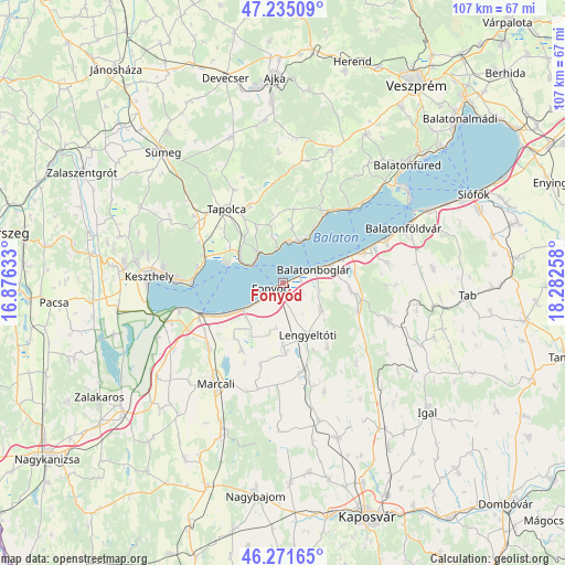
Fonyód GPS coordinates[2]
46° 45' 19.872" North, 17° 34' 46.02" East
| Map corner | latitude | longitude |
|---|---|---|
| Upper-left | 47.23509°, | 16.87633° |
| Center: | 46.75552°, | 17.57945° |
| Lower-right: | 46.27165°, | 18.28258° |
| Map W x H: | 107.1×107.1 km | = 66.5×66.5mi |
| max Lat: | 48.46667° ⇑78.4% North |
| Fonyód: | 46.75552° |
| min Lat: | ⇓21.6% South 45.79108° |
| min Long | Fonyód | max Long |
| 16.27358° | 17.57945° | 22.68096° |
| W 9.5%⇐ | ⇒90.5% E |
Elevation
Elevation of Fonyód is 106 m = 348 ft, and this is 23.7 m = 78 ft below average elevation for this country.
| Max E: |
444 m = 1457 ft | 65.5% |
| Avg. | 129.7 m = 426 ft | |
| Fonyód | 106 m = 348 ft | |
Min E: |
71 m = 233 ft | 34.5% |
See also: Hungary elevation on elevation.city.
Geographical zone
Fonyód is located in North temperate zone (between Tropic of Cancer and the Arctic Circle). Distance of this North polar circle is 2202.4 km =1368.5 mi to North.| Distance of | km | miles | from Fonyód |
|---|---|---|---|
| North Pole | 4808.3 | 2987.7 | to North |
| Arctic Circle | 2202.4 | 1368.5 | to North |
| Tropic Cancer | 2592.8 | 1611.1 | to South |
| Equator | 5198.7 | 3230.3 | to South |


Nearby cities:
15 places around Fonyód: (largest is in red/bold)
• Badacsonytomaj
7.6 km =4.7 mi,  318°
318°
• Balatonberény
20.5 km =12.7 mi,  254°
254°
• Balatonboglár
5.4 km =3.4 mi,  66°
66°
• Balatonfenyves
8 km =5 mi,  236°
236°
• Balatonlelle
9.3 km =5.8 mi, 70°
• Balatonszárszó
20.4 km =12.7 mi, 66°
• Gyenesdiás
22.4 km =13.9 mi,  274°
274°
• Karád
21.2 km =13.2 mi,  109°
109°
• Kéthely
18.7 km =11.6 mi,  229°
229°
• Lengyeltóti
10.7 km =6.6 mi,  152°
152°
• Révfülöp
8.4 km =5.2 mi,  21°
21°
• Somogyvár
20.4 km =12.7 mi,  161°
161°
• Tapolca
17.5 km =10.9 mi, 323°
• Vonyarcvashegy
20.4 km =12.7 mi, 270°
• Zánka
15.2 km =9.4 mi,  31°
31°
Sources, notices
• [Note1] Compared only with cities in Hungary existing in our database
• [Src1] Map data: © OpenStreetMap contributors (CC-BY-SA)
• [Src2] Other city data from geonames.org with taken over terms of usage.
• [Src3] Geographical zone / Annual Mean Temperature by Robert A. Rohde @ Wikipedia
