Keszthely geodata
Keszthely (Zala) is a seat of a second-order administrative division; located in Hungary in Europe/Budapest (GMT+2) time zone. With population of 21,534 people, there are 79 cities with bigger population in this country. Compared to other cities in Hungary, 78% of cities are located further ↑North; 94.9% of cities are located further →East and 62.1% of cities have lower elevation than Keszthely. Note1


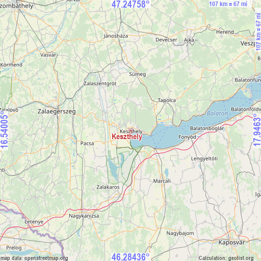
Keszthely GPS coordinates[2]
46° 46' 5.232" North, 17° 14' 35.412" East
| Map corner | latitude | longitude |
|---|---|---|
| Upper-left | 47.24758°, | 16.54005° |
| Center: | 46.76812°, | 17.24317° |
| Lower-right: | 46.28436°, | 17.9463° |
| Map W x H: | 107.1×107.1 km | = 66.5×66.5mi |
| max Lat: | 48.46667° ⇑78% North |
| Keszthely: | 46.76812° |
| min Lat: | ⇓22% South 45.79108° |
| min Long | Keszthely | max Long |
| 16.27358° | 17.24317° | 22.68096° |
| W 5.1%⇐ | ⇒94.9% E |
Elevation
Elevation of Keszthely is 128 m = 420 ft, and this is 1.7 m = 6 ft below average elevation for this country.
| Max E: |
444 m = 1457 ft | 37.9% |
| Avg. | 129.7 m = 426 ft | |
| Keszthely | 128 m = 420 ft | |
Min E: |
71 m = 233 ft | 62.1% |
See also: Hungary elevation on elevation.city.
Geographical zone
Keszthely is located in North temperate zone (between Tropic of Cancer and the Arctic Circle). Distance of this North polar circle is 2201 km =1367.6 mi to North.| Distance of | km | miles | from Keszthely |
|---|---|---|---|
| North Pole | 4806.9 | 2986.9 | to North |
| Arctic Circle | 2201 | 1367.6 | to North |
| Tropic Cancer | 2594.2 | 1612 | to South |
| Equator | 5200.1 | 3231.2 | to South |


Nearby cities:
15 places around Keszthely: (largest is in red/bold)
• Badacsonytomaj
21.1 km =13.1 mi,  78°
78°
• Balatonberény
9 km =5.6 mi,  139°
139°
• Balatonfenyves
19.9 km =12.4 mi,  107°
107°
• Cserszegtomaj
4.1 km =2.5 mi,  335°
335°
• Gyenesdiás
3.3 km =2.1 mi,  85°
85°
• Hévíz
5.1 km =3.2 mi,  298°
298°
• Kéthely
17.8 km =11.1 mi, 139°
• Marcali
24.1 km =15 mi,  147°
147°
• Nemesbük
8.9 km =5.5 mi,  307°
307°
• Pacsa
18.3 km =11.4 mi,  252°
252°
• Sármellék
8.4 km =5.2 mi,  222°
222°
• Sümeg
23.4 km =14.5 mi,  7°
7°
• Tapolca
19.6 km =12.2 mi,  50°
50°
• Vonyarcvashegy
5.4 km =3.4 mi,  102°
102°
• Zalaszentgrót
23.3 km =14.5 mi,  327°
327°
Sources, notices
• [Note1] Compared only with cities in Hungary existing in our database
• [Src1] Map data: © OpenStreetMap contributors (CC-BY-SA)
• [Src2] Other city data from geonames.org with taken over terms of usage.
• [Src3] Geographical zone / Annual Mean Temperature by Robert A. Rohde @ Wikipedia
