Balatonfenyves geodata
Balatonfenyves (Somogy) is a populated place; located in Hungary in Europe/Budapest (GMT+2) time zone. With population of 1,885 people, there are 832 cities with bigger population in this country. Compared to other cities in Hungary, 79.8% of cities are located further ↑North; 91.4% of cities are located further →East and 61.1% of cities have higher elevation than Balatonfenyves. Note1


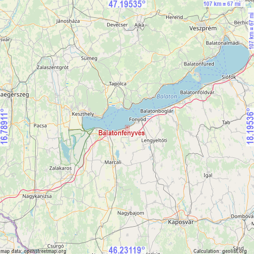
Balatonfenyves GPS coordinates[2]
46° 42' 55.512" North, 17° 29' 32.028" East
| Map corner | latitude | longitude |
|---|---|---|
| Upper-left | 47.19535°, | 16.78911° |
| Center: | 46.71542°, | 17.49223° |
| Lower-right: | 46.23119°, | 18.19536° |
| Map W x H: | 107.2×107.2 km | = 66.6×66.6mi |
| max Lat: | 48.46667° ⇑79.8% North |
| Balatonfenyves: | 46.71542° |
| min Lat: | ⇓20.2% South 45.79108° |
| min Long | Balatonfenyves | max Long |
| 16.27358° | 17.49223° | 22.68096° |
| W 8.6%⇐ | ⇒91.4% E |
Elevation
Elevation of Balatonfenyves is 109 m = 358 ft, and this is 20.7 m = 68 ft below average elevation for this country.
| Max E: |
444 m = 1457 ft | 61.1% |
| Avg. | 129.7 m = 426 ft | |
| Balatonfenyves | 109 m = 358 ft | |
Min E: |
71 m = 233 ft | 38.9% |
See also: Hungary elevation on elevation.city.
Geographical zone
Balatonfenyves is located in North temperate zone (between Tropic of Cancer and the Arctic Circle). Distance of this North polar circle is 2206.9 km =1371.3 mi to North.| Distance of | km | miles | from Balatonfenyves |
|---|---|---|---|
| North Pole | 4812.8 | 2990.5 | to North |
| Arctic Circle | 2206.9 | 1371.3 | to North |
| Tropic Cancer | 2588.3 | 1608.3 | to South |
| Equator | 5194.3 | 3227.6 | to South |


Nearby cities:
15 places around Balatonfenyves: (largest is in red/bold)
• Badacsonytomaj
10.3 km =6.4 mi,  9°
9°
• Balatonberény
13.2 km =8.2 mi,  265°
265°
• Balatonboglár
13.4 km =8.3 mi,  60°
60°
• Balatonlelle
17.2 km =10.7 mi, 63°
• Fonyód
8 km =5 mi, 56°
• Gyenesdiás
16.8 km =10.4 mi,  291°
291°
• Keszthely
19.9 km =12.4 mi, 287°
• Kéthely
10.8 km =6.7 mi,  224°
224°
• Lengyeltóti
12.6 km =7.8 mi,  113°
113°
• Marcali
15.7 km =9.8 mi,  202°
202°
• Révfülöp
15.6 km =9.7 mi,  38°
38°
• Somogyvár
19.8 km =12.3 mi,  138°
138°
• Tapolca
18.9 km =11.7 mi,  348°
348°
• Vonyarcvashegy
14.5 km =9 mi, 288°
• Zánka
22.7 km =14.1 mi, 40°
Sources, notices
• [Note1] Compared only with cities in Hungary existing in our database
• [Src1] Map data: © OpenStreetMap contributors (CC-BY-SA)
• [Src2] Other city data from geonames.org with taken over terms of usage.
• [Src3] Geographical zone / Annual Mean Temperature by Robert A. Rohde @ Wikipedia
