Cserszegtomaj geodata
Cserszegtomaj (Zala) is a populated place; located in Hungary in Europe/Budapest (GMT+2) time zone. With population of 1,941 people, there are 812 cities with bigger population in this country. Compared to other cities in Hungary, 76.8% of cities are located further ↑North; 95% of cities are located further →East and 88.9% of cities have lower elevation than Cserszegtomaj. Note1


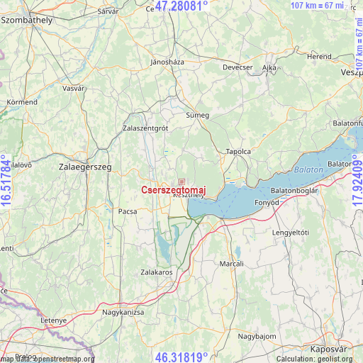
Cserszegtomaj GPS coordinates[2]
46° 48' 5.94" North, 17° 13' 15.456" East
| Map corner | latitude | longitude |
|---|---|---|
| Upper-left | 47.28081°, | 16.51784° |
| Center: | 46.80165°, | 17.22096° |
| Lower-right: | 46.31819°, | 17.92409° |
| Map W x H: | 107×107 km | = 66.5×66.5mi |
| max Lat: | 48.46667° ⇑76.8% North |
| Cserszegtomaj: | 46.80165° |
| min Lat: | ⇓23.2% South 45.79108° |
| min Long | Cserszegtomaj | max Long |
| 16.27358° | 17.22096° | 22.68096° |
| W 5%⇐ | ⇒95% E |
Elevation
Elevation of Cserszegtomaj is 183 m = 600 ft, and this is 53.3 m = 175 ft above average elevation for this country.
| Max E: |
444 m = 1457 ft | 11.1% |
| Cserszegtomaj | 183 m 600 ft | |
| Avg. | 129.7 m = 426 ft | |
Min E: |
71 m = 233 ft | 88.9% |
See also: Hungary elevation on elevation.city.
Geographical zone
Cserszegtomaj is located in North temperate zone (between Tropic of Cancer and the Arctic Circle). Distance of this North polar circle is 2197.3 km =1365.3 mi to North.| Distance of | km | miles | from Cserszegtomaj |
|---|---|---|---|
| North Pole | 4803.2 | 2984.6 | to North |
| Arctic Circle | 2197.3 | 1365.3 | to North |
| Tropic Cancer | 2597.9 | 1614.3 | to South |
| Equator | 5203.9 | 3233.6 | to South |


Nearby cities:
15 places around Cserszegtomaj: (largest is in red/bold)
• Badacsonytomaj
22.3 km =13.9 mi,  88°
88°
• Balatonberény
13 km =8.1 mi,  144°
144°
• Balatonfenyves
22.8 km =14.2 mi,  114°
114°
• Gyenesdiás
6.1 km =3.8 mi,  124°
124°
• Hévíz
3.1 km =1.9 mi,  245°
245°
• Keszthely
4.1 km =2.5 mi,  155°
155°
• Kéthely
21.7 km =13.5 mi, 142°
• Nemesbük
5.7 km =3.5 mi,  287°
287°
• Pacsa
18.2 km =11.3 mi,  240°
240°
• Sármellék
10.7 km =6.6 mi,  201°
201°
• Sümeg
20 km =12.4 mi,  13°
13°
• Tapolca
19 km =11.8 mi,  62°
62°
• Türje
22 km =13.7 mi,  336°
336°
• Vonyarcvashegy
8.5 km =5.3 mi,  125°
125°
• Zalaszentgrót
19.2 km =11.9 mi,  325°
325°
Sources, notices
• [Note1] Compared only with cities in Hungary existing in our database
• [Src1] Map data: © OpenStreetMap contributors (CC-BY-SA)
• [Src2] Other city data from geonames.org with taken over terms of usage.
• [Src3] Geographical zone / Annual Mean Temperature by Robert A. Rohde @ Wikipedia
