Tar geodata
Tar (Nógrád) is a populated place; located in Hungary in Europe/Budapest (GMT+2) time zone. With population of 1,972 people, there are 798 cities with bigger population in this country. Compared to other cities in Hungary, 85.3% of cities are located further ↓South; 56% of cities are located further ←West and 84.5% of cities have lower elevation than Tar. Note1


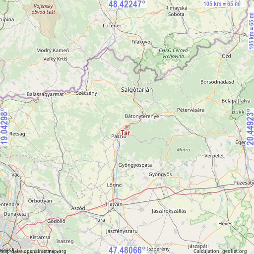
Tar GPS coordinates[2]
47° 57' 13.356" North, 19° 44' 45.96" East
| Map corner | latitude | longitude |
|---|---|---|
| Upper-left | 48.42247°, | 19.04298° |
| Center: | 47.95371°, | 19.7461° |
| Lower-right: | 47.48066°, | 20.44923° |
| Map W x H: | 104.7×104.7 km | = 65.1×65.1mi |
| max Lat: | 48.46667° ⇑14.7% North |
| Tar: | 47.95371° |
| min Lat: | ⇓85.3% South 45.79108° |
| min Long | Tar | max Long |
| 16.27358° | 19.7461° | 22.68096° |
| W 56%⇐ | ⇒44% E |
Elevation
Elevation of Tar is 171 m = 561 ft, and this is 41.3 m = 135 ft above average elevation for this country.
| Max E: |
444 m = 1457 ft | 15.5% |
| Tar | 171 m 561 ft | |
| Avg. | 129.7 m = 426 ft | |
Min E: |
71 m = 233 ft | 84.5% |
See also: Hungary elevation on elevation.city.
Geographical zone
Tar is located in North temperate zone (between Tropic of Cancer and the Arctic Circle). Distance of this North polar circle is 2069.2 km =1285.7 mi to North.| Distance of | km | miles | from Tar |
|---|---|---|---|
| North Pole | 4675.1 | 2905 | to North |
| Arctic Circle | 2069.2 | 1285.7 | to North |
| Tropic Cancer | 2726 | 1693.9 | to South |
| Equator | 5332 | 3313.2 | to South |


Nearby cities:
15 places around Tar: (largest is in red/bold)
• Apc
18.2 km =11.3 mi,  192°
192°
• Buják
17 km =10.6 mi,  242°
242°
• Bátonyterenye
7.3 km =4.5 mi,  75°
75°
• Gyöngyöspata
15.7 km =9.8 mi,  168°
168°
• Gyöngyöstarján
18 km =11.2 mi,  149°
149°
• Jobbágyi
14.4 km =8.9 mi,  200°
200°
• Kazár
13.7 km =8.5 mi,  38°
38°
• Mátraterenye
17.4 km =10.8 mi,  59°
59°
• Mátraverebély
3.4 km =2.1 mi,  48°
48°
• Parádsasvár
17.8 km =11.1 mi,  104°
104°
• Pásztó
5.2 km =3.2 mi,  223°
223°
• Rimóc
18.5 km =11.5 mi,  299°
299°
• Rózsaszentmárton
19.1 km =11.9 mi,  180°
180°
• Salgótarján
16.7 km =10.4 mi,  14°
14°
• Szurdokpüspöki
11.2 km =7 mi, 200°
Sources, notices
• [Note1] Compared only with cities in Hungary existing in our database
• [Src1] Map data: © OpenStreetMap contributors (CC-BY-SA)
• [Src2] Other city data from geonames.org with taken over terms of usage.
• [Src3] Geographical zone / Annual Mean Temperature by Robert A. Rohde @ Wikipedia
