Székesfehérvár geodata
Székesfehérvár (Fejér) is a seat of a first-order administrative division; located in Hungary in Europe/Budapest (GMT+2) time zone. With population of 101,600 people, there are 12 cities with bigger population in this country. Compared to other cities in Hungary, 62.1% of cities are located further ↑North; 78.7% of cities are located further →East and 51.5% of cities have lower elevation than Székesfehérvár. Note1


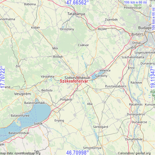
Székesfehérvár GPS coordinates[2]
47° 11' 23.82" North, 18° 24' 37.224" East
| Map corner | latitude | longitude |
|---|---|---|
| Upper-left | 47.66562°, | 17.70722° |
| Center: | 47.18995°, | 18.41034° |
| Lower-right: | 46.70998°, | 19.11347° |
| Map W x H: | 106.3×106.3 km | = 66.1×66.1mi |
| max Lat: | 48.46667° ⇑62.1% North |
| Székesfehérvár: | 47.18995° |
| min Lat: | ⇓37.9% South 45.79108° |
| min Long | Székesfehérv� | max Long |
| 16.27358° | 18.41034° | 22.68096° |
| W 21.3%⇐ | ⇒78.7% E |
Elevation
Elevation of Székesfehérvár is 117 m = 384 ft, and this is 12.7 m = 42 ft below average elevation for this country.
| Max E: |
444 m = 1457 ft | 48.5% |
| Avg. | 129.7 m = 426 ft | |
| Székesfehérvár | 117 m = 384 ft | |
Min E: |
71 m = 233 ft | 51.5% |
See also: Székesfehérvár elevation on elevation.city.
Geographical zone
Székesfehérvár is located in North temperate zone (between Tropic of Cancer and the Arctic Circle). Distance of this North polar circle is 2154.1 km =1338.5 mi to North.| Distance of | km | miles | from Székesfehérvár |
|---|---|---|---|
| North Pole | 4760 | 2957.7 | to North |
| Arctic Circle | 2154.1 | 1338.5 | to North |
| Tropic Cancer | 2641.1 | 1641.1 | to South |
| Equator | 5247 | 3260.3 | to South |


Nearby cities:
15 places around Székesfehérvár: (largest is in red/bold)
• Aba
19.8 km =12.3 mi,  154°
154°
• Bodajk
20 km =12.4 mi,  317°
317°
• Fehérvárcsurgó
15.9 km =9.9 mi, 316°
• Gárdony
17.2 km =10.7 mi,  82°
82°
• Kincsesbánya
13 km =8.1 mi,  309°
309°
• Lovasberény
17.1 km =10.6 mi,  38°
38°
• Polgárdi
16.5 km =10.3 mi,  209°
209°
• Pákozd
9.6 km =6 mi,  74°
74°
• Seregélyes
14.7 km =9.1 mi,  127°
127°
• Soponya
19.7 km =12.2 mi,  170°
170°
• Szabadbattyán
8.5 km =5.3 mi,  201°
201°
• Sárszentmihály
6.8 km =4.2 mi,  232°
232°
• Velence
19.2 km =11.9 mi, 73°
• Zámoly
14.1 km =8.8 mi,  359°
359°
• Ősi
17.4 km =10.8 mi,  254°
254°
In other languages:
- In German: Székesfehérvár, Stuhlweißenburg
- In Italian: Albareale
- In Russian: Секешфехервар
- In Chinese: 塞克什白堡
Sources, notices
• [Note1] Compared only with cities in Hungary existing in our database
• [Src1] Map data: © OpenStreetMap contributors (CC-BY-SA)
• [Src2] Other city data from geonames.org with taken over terms of usage.
• [Src3] Geographical zone / Annual Mean Temperature by Robert A. Rohde @ Wikipedia
