Polgárdi geodata
Polgárdi (Fejér) is a seat of a second-order administrative division; located in Hungary in Europe/Budapest (GMT+2) time zone. With population of 6,564 people, there are 232 cities with bigger population in this country. Compared to other cities in Hungary, 66.8% of cities are located further ↑North; 80.9% of cities are located further →East and 77.4% of cities have lower elevation than Polgárdi. Note1


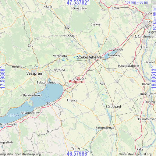
Polgárdi GPS coordinates[2]
47° 3' 39.564" North, 18° 18' 7.2" East
| Map corner | latitude | longitude |
|---|---|---|
| Upper-left | 47.53782°, | 17.59888° |
| Center: | 47.06099°, | 18.302° |
| Lower-right: | 46.57986°, | 19.00513° |
| Map W x H: | 106.5×106.5 km | = 66.2×66.2mi |
| max Lat: | 48.46667° ⇑66.8% North |
| Polgárdi: | 47.06099° |
| min Lat: | ⇓33.2% South 45.79108° |
| min Long | Polgárdi | max Long |
| 16.27358° | 18.302° | 22.68096° |
| W 19.1%⇐ | ⇒80.9% E |
Elevation
Elevation of Polgárdi is 151 m = 495 ft, and this is 21.3 m = 70 ft above average elevation for this country.
| Max E: |
444 m = 1457 ft | 22.6% |
| Polgárdi | 151 m 495 ft | |
| Avg. | 129.7 m = 426 ft | |
Min E: |
71 m = 233 ft | 77.4% |
See also: Hungary elevation on elevation.city.
Geographical zone
Polgárdi is located in North temperate zone (between Tropic of Cancer and the Arctic Circle). Distance of this North polar circle is 2168.5 km =1347.4 mi to North.| Distance of | km | miles | from Polgárdi |
|---|---|---|---|
| North Pole | 4774.4 | 2966.7 | to North |
| Arctic Circle | 2168.5 | 1347.4 | to North |
| Tropic Cancer | 2626.8 | 1632.2 | to South |
| Equator | 5232.7 | 3251.4 | to South |


Nearby cities:
15 places around Polgárdi: (largest is in red/bold)
• Aba
17 km =10.6 mi,  102°
102°
• Balatonkenese
15 km =9.3 mi,  261°
261°
• Berhida
14.2 km =8.8 mi,  293°
293°
• Enying
15.2 km =9.4 mi,  197°
197°
• Kisláng
13.2 km =8.2 mi,  150°
150°
• Káloz
18.1 km =11.2 mi,  130°
130°
• Lepsény
9 km =5.6 mi,  209°
209°
• Pétfürdő
18.3 km =11.4 mi,  309°
309°
• Soponya
12.6 km =7.8 mi,  114°
114°
• Szabadbattyán
8.2 km =5.1 mi,  37°
37°
• Székesfehérvár
16.5 km =10.3 mi,  29°
29°
• Sárkeresztúr
19.3 km =12 mi, 108°
• Sárszentmihály
10.6 km =6.6 mi,  15°
15°
• Várpalota
19.7 km =12.2 mi,  321°
321°
• Ősi
12.9 km =8 mi, 318°
Sources, notices
• [Note1] Compared only with cities in Hungary existing in our database
• [Src1] Map data: © OpenStreetMap contributors (CC-BY-SA)
• [Src2] Other city data from geonames.org with taken over terms of usage.
• [Src3] Geographical zone / Annual Mean Temperature by Robert A. Rohde @ Wikipedia
