Bodajk geodata
Bodajk (Fejér) is a populated place; located in Hungary in Europe/Budapest (GMT+2) time zone. With population of 4,069 people, there are 372 cities with bigger population in this country. Compared to other cities in Hungary, 55.3% of cities are located further ↑North; 82.6% of cities are located further →East and 77.7% of cities have lower elevation than Bodajk. Note1


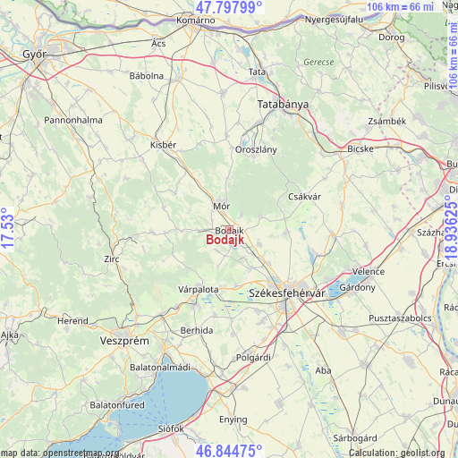
Bodajk GPS coordinates[2]
47° 19' 24.672" North, 18° 13' 59.232" East
| Map corner | latitude | longitude |
|---|---|---|
| Upper-left | 47.79799°, | 17.53° |
| Center: | 47.32352°, | 18.23312° |
| Lower-right: | 46.84475°, | 18.93625° |
| Map W x H: | 106×106 km | = 65.9×65.9mi |
| max Lat: | 48.46667° ⇑55.3% North |
| Bodajk: | 47.32352° |
| min Lat: | ⇓44.7% South 45.79108° |
| min Long | Bodajk | max Long |
| 16.27358° | 18.23312° | 22.68096° |
| W 17.4%⇐ | ⇒82.6% E |
Elevation
Elevation of Bodajk is 152 m = 499 ft, and this is 22.3 m = 73 ft above average elevation for this country.
| Max E: |
444 m = 1457 ft | 22.3% |
| Bodajk | 152 m 499 ft | |
| Avg. | 129.7 m = 426 ft | |
Min E: |
71 m = 233 ft | 77.7% |
See also: Hungary elevation on elevation.city.
Geographical zone
Bodajk is located in North temperate zone (between Tropic of Cancer and the Arctic Circle). Distance of this North polar circle is 2139.3 km =1329.3 mi to North.| Distance of | km | miles | from Bodajk |
|---|---|---|---|
| North Pole | 4745.2 | 2948.5 | to North |
| Arctic Circle | 2139.3 | 1329.3 | to North |
| Tropic Cancer | 2656 | 1650.4 | to South |
| Equator | 5261.9 | 3269.6 | to South |


Nearby cities:
15 places around Bodajk: (largest is in red/bold)
• Bakonycsernye
11.9 km =7.4 mi,  270°
270°
• Bokod
18.7 km =11.6 mi,  3°
3°
• Csetény
18.2 km =11.3 mi, 268°
• Csákvár
19 km =11.8 mi,  66°
66°
• Fehérvárcsurgó
4.1 km =2.5 mi,  144°
144°
• Kincsesbánya
7.4 km =4.6 mi,  152°
152°
• Mór
6.4 km =4 mi,  339°
339°
• Oroszlány
19.1 km =11.9 mi,  18°
18°
• Pusztavám
11.8 km =7.3 mi,  357°
357°
• Pétfürdő
19.5 km =12.1 mi,  206°
206°
• Székesfehérvár
20 km =12.4 mi, 137°
• Sárszentmihály
20.5 km =12.7 mi,  157°
157°
• Várpalota
15.5 km =9.6 mi, 207°
• Zámoly
13.2 km =8.2 mi,  93°
93°
• Ősi
19.9 km =12.4 mi,  189°
189°
Sources, notices
• [Note1] Compared only with cities in Hungary existing in our database
• [Src1] Map data: © OpenStreetMap contributors (CC-BY-SA)
• [Src2] Other city data from geonames.org with taken over terms of usage.
• [Src3] Geographical zone / Annual Mean Temperature by Robert A. Rohde @ Wikipedia
