Kincsesbánya geodata
Kincsesbánya (Fejér) is a populated place; located in Hungary in Europe/Budapest (GMT+2) time zone. With population of 1,506 people, there are 859 cities with bigger population in this country. Compared to other cities in Hungary, 58.6% of cities are located further ↑North; 81.3% of cities are located further →East and 71% of cities have lower elevation than Kincsesbánya. Note1


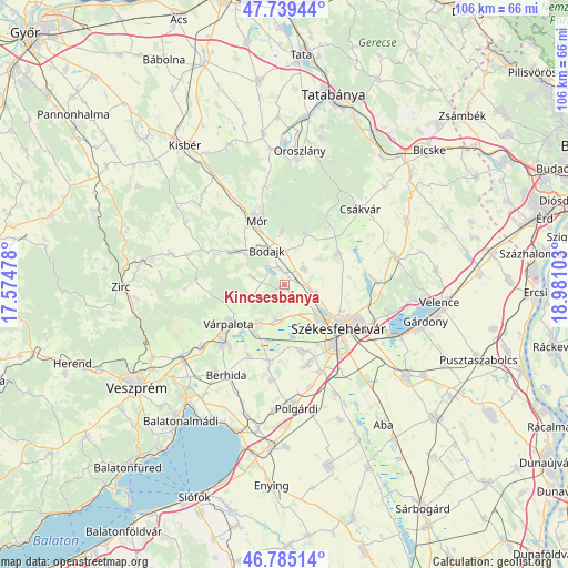
Kincsesbánya GPS coordinates[2]
47° 15' 51.984" North, 18° 16' 40.44" East
| Map corner | latitude | longitude |
|---|---|---|
| Upper-left | 47.73944°, | 17.57478° |
| Center: | 47.26444°, | 18.2779° |
| Lower-right: | 46.78514°, | 18.98103° |
| Map W x H: | 106.1×106.1 km | = 65.9×65.9mi |
| max Lat: | 48.46667° ⇑58.6% North |
| Kincsesbánya: | 47.26444° |
| min Lat: | ⇓41.4% South 45.79108° |
| min Long | Kincsesbánya | max Long |
| 16.27358° | 18.2779° | 22.68096° |
| W 18.7%⇐ | ⇒81.3% E |
Elevation
Elevation of Kincsesbánya is 139 m = 456 ft, and this is 9.3 m = 31 ft above average elevation for this country.
| Max E: |
444 m = 1457 ft | 29% |
| Kincsesbánya | 139 m 456 ft | |
| Avg. | 129.7 m = 426 ft | |
Min E: |
71 m = 233 ft | 71% |
See also: Hungary elevation on elevation.city.
Geographical zone
Kincsesbánya is located in North temperate zone (between Tropic of Cancer and the Arctic Circle). Distance of this North polar circle is 2145.9 km =1333.4 mi to North.| Distance of | km | miles | from Kincsesbánya |
|---|---|---|---|
| North Pole | 4751.7 | 2952.6 | to North |
| Arctic Circle | 2145.9 | 1333.4 | to North |
| Tropic Cancer | 2649.4 | 1646.3 | to South |
| Equator | 5255.3 | 3265.5 | to South |


Nearby cities:
15 places around Kincsesbánya: (largest is in red/bold)
• Bakonycsernye
16.7 km =10.4 mi,  293°
293°
• Berhida
20.4 km =12.7 mi,  213°
213°
• Bodajk
7.4 km =4.6 mi,  332°
332°
• Csákvár
20 km =12.4 mi,  44°
44°
• Fehérvárcsurgó
3.4 km =2.1 mi,  342°
342°
• Mór
13.8 km =8.6 mi, 336°
• Pusztavám
18.8 km =11.7 mi,  348°
348°
• Pákozd
20.1 km =12.5 mi,  106°
106°
• Pétfürdő
16.3 km =10.1 mi,  228°
228°
• Szabadbattyán
17.6 km =10.9 mi,  157°
157°
• Székesfehérvár
13 km =8.1 mi,  129°
129°
• Sárszentmihály
13.2 km =8.2 mi, 159°
• Várpalota
12.7 km =7.9 mi,  235°
235°
• Zámoly
11.4 km =7.1 mi,  59°
59°
• Ősi
14.7 km =9.1 mi, 207°
Sources, notices
• [Note1] Compared only with cities in Hungary existing in our database
• [Src1] Map data: © OpenStreetMap contributors (CC-BY-SA)
• [Src2] Other city data from geonames.org with taken over terms of usage.
• [Src3] Geographical zone / Annual Mean Temperature by Robert A. Rohde @ Wikipedia
