Szabadbattyán geodata
Szabadbattyán (Fejér) is a populated place; located in Hungary in Europe/Budapest (GMT+2) time zone. With population of 4,492 people, there are 332 cities with bigger population in this country. Compared to other cities in Hungary, 64.8% of cities are located further ↑North; 79.5% of cities are located further →East and 59.7% of cities have higher elevation than Szabadbattyán. Note1


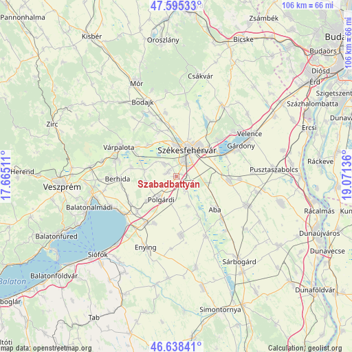
Szabadbattyán GPS coordinates[2]
47° 7' 8.472" North, 18° 22' 5.628" East
| Map corner | latitude | longitude |
|---|---|---|
| Upper-left | 47.59533°, | 17.66511° |
| Center: | 47.11902°, | 18.36823° |
| Lower-right: | 46.63841°, | 19.07136° |
| Map W x H: | 106.4×106.4 km | = 66.1×66.1mi |
| max Lat: | 48.46667° ⇑64.8% North |
| Szabadbattyán: | 47.11902° |
| min Lat: | ⇓35.2% South 45.79108° |
| min Long | Szabadbattyán | max Long |
| 16.27358° | 18.36823° | 22.68096° |
| W 20.5%⇐ | ⇒79.5% E |
Elevation
Elevation of Szabadbattyán is 110 m = 361 ft, and this is 19.7 m = 65 ft below average elevation for this country.
| Max E: |
444 m = 1457 ft | 59.7% |
| Avg. | 129.7 m = 426 ft | |
| Szabadbattyán | 110 m = 361 ft | |
Min E: |
71 m = 233 ft | 40.3% |
See also: Hungary elevation on elevation.city.
Geographical zone
Szabadbattyán is located in North temperate zone (between Tropic of Cancer and the Arctic Circle). Distance of this North polar circle is 2162 km =1343.4 mi to North.| Distance of | km | miles | from Szabadbattyán |
|---|---|---|---|
| North Pole | 4767.9 | 2962.6 | to North |
| Arctic Circle | 2162 | 1343.4 | to North |
| Tropic Cancer | 2633.2 | 1636.2 | to South |
| Equator | 5239.1 | 3255.4 | to South |


Nearby cities:
15 places around Szabadbattyán: (largest is in red/bold)
• Aba
15.3 km =9.5 mi,  130°
130°
• Berhida
18.1 km =11.2 mi,  267°
267°
• Kincsesbánya
17.6 km =10.9 mi,  337°
337°
• Kisláng
18 km =11.2 mi,  175°
175°
• Lepsény
17.1 km =10.6 mi,  213°
213°
• Polgárdi
8.2 km =5.1 mi,  217°
217°
• Pákozd
16.3 km =10.1 mi,  49°
49°
• Pétfürdő
19.7 km =12.2 mi,  285°
285°
• Seregélyes
14.9 km =9.3 mi,  93°
93°
• Soponya
13.3 km =8.3 mi,  150°
150°
• Székesfehérvár
8.5 km =5.3 mi,  21°
21°
• Sárkeresztúr
18.3 km =11.4 mi, 133°
• Sárszentmihály
4.4 km =2.7 mi,  329°
329°
• Várpalota
19.5 km =12.1 mi,  297°
297°
• Ősi
14 km =8.7 mi,  282°
282°
Sources, notices
• [Note1] Compared only with cities in Hungary existing in our database
• [Src1] Map data: © OpenStreetMap contributors (CC-BY-SA)
• [Src2] Other city data from geonames.org with taken over terms of usage.
• [Src3] Geographical zone / Annual Mean Temperature by Robert A. Rohde @ Wikipedia
