Ősi geodata
Ősi (Veszprém) is a populated place; located in Hungary in Europe/Budapest (GMT+2) time zone. With population of 2,146 people, there are 730 cities with bigger population in this country. Compared to other cities in Hungary, 63.5% of cities are located further ↑North; 83.1% of cities are located further →East and 59.7% of cities have higher elevation than Ősi. Note1


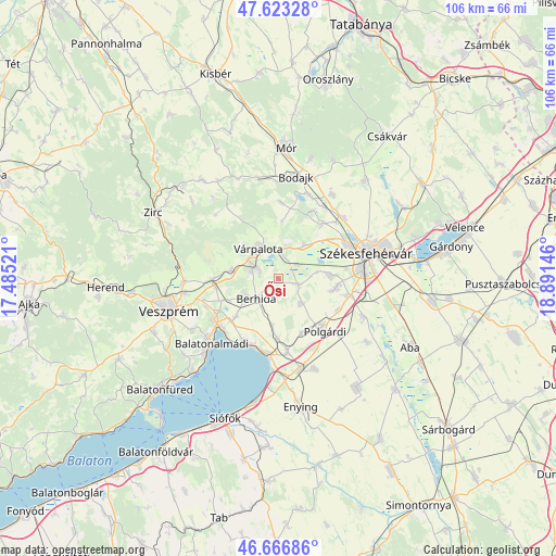
Ősi GPS coordinates[2]
47° 8' 49.992" North, 18° 11' 17.988" East
| Map corner | latitude | longitude |
|---|---|---|
| Upper-left | 47.62328°, | 17.48521° |
| Center: | 47.14722°, | 18.18833° |
| Lower-right: | 46.66686°, | 18.89146° |
| Map W x H: | 106.3×106.3 km | = 66.1×66.1mi |
| max Lat: | 48.46667° ⇑63.5% North |
| Ősi: | 47.14722° |
| min Lat: | ⇓36.5% South 45.79108° |
| min Long | Ősi | max Long |
| 16.27358° | 18.18833° | 22.68096° |
| W 16.9%⇐ | ⇒83.1% E |
Elevation
Elevation of Ősi is 110 m = 361 ft, and this is 19.7 m = 65 ft below average elevation for this country.
| Max E: |
444 m = 1457 ft | 59.7% |
| Avg. | 129.7 m = 426 ft | |
| Ősi | 110 m = 361 ft | |
Min E: |
71 m = 233 ft | 40.3% |
See also: Hungary elevation on elevation.city.
Geographical zone
Ősi is located in North temperate zone (between Tropic of Cancer and the Arctic Circle). Distance of this North polar circle is 2158.9 km =1341.5 mi to North.| Distance of | km | miles | from Ősi |
|---|---|---|---|
| North Pole | 4764.8 | 2960.7 | to North |
| Arctic Circle | 2158.9 | 1341.5 | to North |
| Tropic Cancer | 2636.4 | 1638.2 | to South |
| Equator | 5242.3 | 3257.4 | to South |


Nearby cities:
15 places around Ősi: (largest is in red/bold)
• Balatonalmádi
17.8 km =11.1 mi,  225°
225°
• Balatonkenese
13.4 km =8.3 mi,  207°
207°
• Berhida
6 km =3.7 mi, 228°
• Fehérvárcsurgó
17.3 km =10.7 mi,  19°
19°
• Hajmáskér
12.8 km =8 mi,  268°
268°
• Kincsesbánya
14.7 km =9.1 mi,  27°
27°
• Lepsény
17.9 km =11.1 mi,  166°
166°
• Litér
14.8 km =9.2 mi,  249°
249°
• Polgárdi
12.9 km =8 mi,  138°
138°
• Pétfürdő
5.8 km =3.6 mi,  291°
291°
• Szabadbattyán
14 km =8.7 mi,  102°
102°
• Szentkirályszabadja
19.3 km =12 mi,  238°
238°
• Székesfehérvár
17.4 km =10.8 mi,  74°
74°
• Sárszentmihály
11.4 km =7.1 mi,  86°
86°
• Várpalota
6.9 km =4.3 mi,  327°
327°
Sources, notices
• [Note1] Compared only with cities in Hungary existing in our database
• [Src1] Map data: © OpenStreetMap contributors (CC-BY-SA)
• [Src2] Other city data from geonames.org with taken over terms of usage.
• [Src3] Geographical zone / Annual Mean Temperature by Robert A. Rohde @ Wikipedia
