Somoskőújfalu geodata
Somoskőújfalu (Nógrád) is a populated place; located in Hungary in Europe/Budapest (GMT+2) time zone. With population of 2,296 people, there are 672 cities with bigger population in this country. Compared to other cities in Hungary, 94.7% of cities are located further ↓South; 57.6% of cities are located further ←West and 99.1% of cities have lower elevation than Somoskőújfalu. Note1


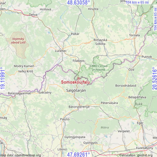
Somoskőújfalu GPS coordinates[2]
48° 9' 49.464" North, 19° 49' 22.908" East
| Map corner | latitude | longitude |
|---|---|---|
| Upper-left | 48.63058°, | 19.11991° |
| Center: | 48.16374°, | 19.82303° |
| Lower-right: | 47.69261°, | 20.52616° |
| Map W x H: | 104.3×104.3 km | = 64.8×64.8mi |
| max Lat: | 48.46667° ⇑5.3% North |
| Somoskőújfalu: | 48.16374° |
| min Lat: | ⇓94.7% South 45.79108° |
| min Long | Somoskőújfalu | max Long |
| 16.27358° | 19.82303° | 22.68096° |
| W 57.6%⇐ | ⇒42.4% E |
Elevation
Elevation of Somoskőújfalu is 310 m = 1017 ft, and this is 180.3 m = 592 ft above average elevation for this country.
| Max E: |
444 m = 1457 ft | 0.90000000000001% |
| Somoskőújfalu | 310 m 1017 ft | |
| Avg. | 129.7 m = 426 ft | |
Min E: |
71 m = 233 ft | 99.1% |
See also: Hungary elevation on elevation.city.
Geographical zone
Somoskőújfalu is located in North temperate zone (between Tropic of Cancer and the Arctic Circle). Distance of this North polar circle is 2045.9 km =1271.3 mi to North.| Distance of | km | miles | from Somoskőújfalu |
|---|---|---|---|
| North Pole | 4651.8 | 2890.5 | to North |
| Arctic Circle | 2045.9 | 1271.3 | to North |
| Tropic Cancer | 2749.4 | 1708.4 | to South |
| Equator | 5355.3 | 3327.6 | to South |


Nearby cities:
15 places around Somoskőújfalu: (largest is in red/bold)
• Bátonyterenye
21.6 km =13.4 mi,  176°
176°
• Karancskeszi
9.4 km =5.8 mi,  269°
269°
• Karancslapujtő
6.8 km =4.2 mi,  257°
257°
• Kazár
13 km =8.1 mi,  167°
167°
• Mátranovák
18.3 km =11.4 mi,  139°
139°
• Mátraterenye
17.3 km =10.7 mi,  147°
147°
• Mátraverebély
21.3 km =13.2 mi,  188°
188°
• Parádsasvár
30.2 km =18.8 mi,  157°
157°
• Pásztó
28.6 km =17.8 mi,  198°
198°
• Pétervására
26.3 km =16.3 mi,  128°
128°
• Rimóc
25.9 km =16.1 mi,  237°
237°
• Salgótarján
7.4 km =4.6 mi, 191°
• Szécsény
24.3 km =15.1 mi,  247°
247°
• Tar
24 km =14.9 mi, 193°
• Tarnalelesz
29.6 km =18.4 mi,  115°
115°
Sources, notices
• [Note1] Compared only with cities in Hungary existing in our database
• [Src1] Map data: © OpenStreetMap contributors (CC-BY-SA)
• [Src2] Other city data from geonames.org with taken over terms of usage.
• [Src3] Geographical zone / Annual Mean Temperature by Robert A. Rohde @ Wikipedia
