Salgótarján geodata
Salgótarján (Nógrád) is a seat of a first-order administrative division; located in Hungary in Europe/Budapest (GMT+2) time zone. With population of 39,640 people, there are 44 cities with bigger population in this country. Compared to other cities in Hungary, 91.2% of cities are located further ↓South; 57.5% of cities are located further ←West and 96.8% of cities have lower elevation than Salgótarján. Note1


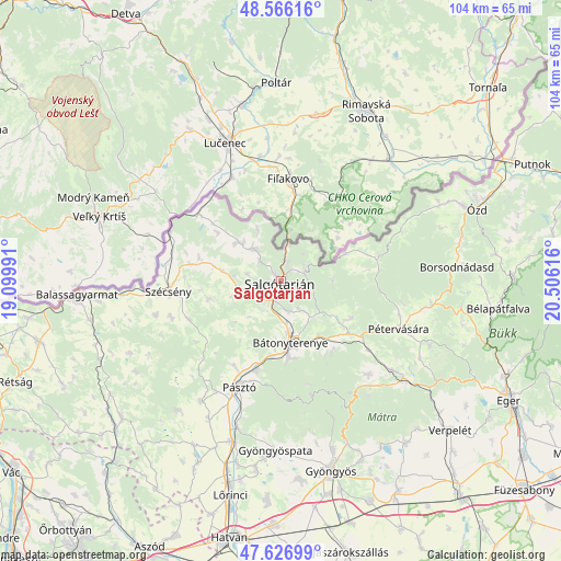
Salgótarján GPS coordinates[2]
48° 5' 55.392" North, 19° 48' 10.908" East
| Map corner | latitude | longitude |
|---|---|---|
| Upper-left | 48.56616°, | 19.09991° |
| Center: | 48.09872°, | 19.80303° |
| Lower-right: | 47.62699°, | 20.50616° |
| Map W x H: | 104.4×104.4 km | = 64.9×64.9mi |
| max Lat: | 48.46667° ⇑8.8% North |
| Salgótarján: | 48.09872° |
| min Lat: | ⇓91.2% South 45.79108° |
| min Long | Salgótarján | max Long |
| 16.27358° | 19.80303° | 22.68096° |
| W 57.5%⇐ | ⇒42.5% E |
Elevation
Elevation of Salgótarján is 242 m = 794 ft, and this is 112.3 m = 368 ft above average elevation for this country.
| Max E: |
444 m = 1457 ft | 3.2% |
| Salgótarján | 242 m 794 ft | |
| Avg. | 129.7 m = 426 ft | |
Min E: |
71 m = 233 ft | 96.8% |
See also: Hungary elevation on elevation.city.
Geographical zone
Salgótarján is located in North temperate zone (between Tropic of Cancer and the Arctic Circle). Distance of this North polar circle is 2053.1 km =1275.7 mi to North.| Distance of | km | miles | from Salgótarján |
|---|---|---|---|
| North Pole | 4659 | 2895 | to North |
| Arctic Circle | 2053.1 | 1275.7 | to North |
| Tropic Cancer | 2742.2 | 1703.9 | to South |
| Equator | 5348.1 | 3323.2 | to South |


Nearby cities:
15 places around Salgótarján: (largest is in red/bold)
• Bátonyterenye
14.6 km =9.1 mi,  168°
168°
• Karancskeszi
10.7 km =6.6 mi,  312°
312°
• Karancslapujtő
7.7 km =4.8 mi,  317°
317°
• Kazár
7 km =4.3 mi,  141°
141°
• Mátranovák
14.9 km =9.3 mi,  116°
116°
• Mátraterenye
13 km =8.1 mi, 124°
• Mátraverebély
13.9 km =8.6 mi,  186°
186°
• Parád
25.8 km =16 mi, 139°
• Parádsasvár
24.4 km =15.2 mi,  147°
147°
• Pásztó
21.3 km =13.2 mi,  201°
201°
• Pétervására
23.9 km =14.9 mi,  112°
112°
• Rimóc
21.4 km =13.3 mi,  251°
251°
• Somoskőújfalu
7.4 km =4.6 mi,  11°
11°
• Szécsény
21.1 km =13.1 mi,  264°
264°
• Tar
16.7 km =10.4 mi, 194°
Sources, notices
• [Note1] Compared only with cities in Hungary existing in our database
• [Src1] Map data: © OpenStreetMap contributors (CC-BY-SA)
• [Src2] Other city data from geonames.org with taken over terms of usage.
• [Src3] Geographical zone / Annual Mean Temperature by Robert A. Rohde @ Wikipedia
