Segesd geodata
Segesd (Somogy) is a populated place; located in Hungary in Europe/Budapest (GMT+2) time zone. With population of 2,674 people, there are 575 cities with bigger population in this country. Compared to other cities in Hungary, 90.9% of cities are located further ↑North; 93.5% of cities are located further →East and 82.9% of cities have lower elevation than Segesd. Note1


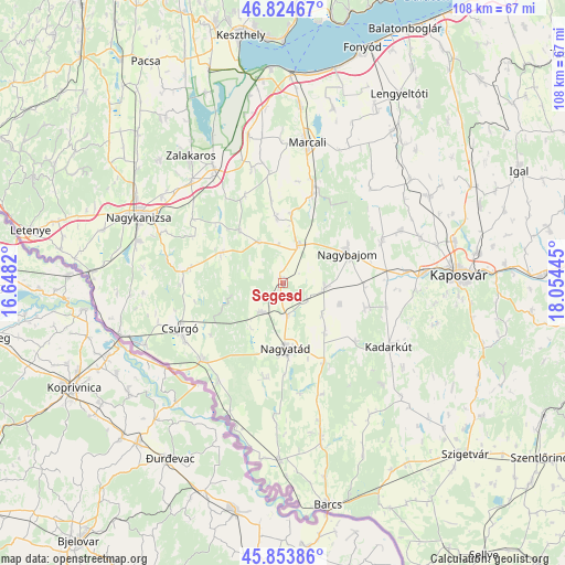
Segesd GPS coordinates[2]
46° 20' 29.112" North, 17° 21' 4.752" East
| Map corner | latitude | longitude |
|---|---|---|
| Upper-left | 46.82467°, | 16.6482° |
| Center: | 46.34142°, | 17.35132° |
| Lower-right: | 45.85386°, | 18.05445° |
| Map W x H: | 107.9×107.9 km | = 67×67mi |
| max Lat: | 48.46667° ⇑90.9% North |
| Segesd: | 46.34142° |
| min Lat: | ⇓9.1% South 45.79108° |
| min Long | Segesd | max Long |
| 16.27358° | 17.35132° | 22.68096° |
| W 6.5%⇐ | ⇒93.5% E |
Elevation
Elevation of Segesd is 167 m = 548 ft, and this is 37.3 m = 122 ft above average elevation for this country.
| Max E: |
444 m = 1457 ft | 17.1% |
| Segesd | 167 m 548 ft | |
| Avg. | 129.7 m = 426 ft | |
Min E: |
71 m = 233 ft | 82.9% |
See also: Hungary elevation on elevation.city.
Geographical zone
Segesd is located in North temperate zone (between Tropic of Cancer and the Arctic Circle). Distance of this North polar circle is 2248.5 km =1397.2 mi to North.| Distance of | km | miles | from Segesd |
|---|---|---|---|
| North Pole | 4854.4 | 3016.4 | to North |
| Arctic Circle | 2248.5 | 1397.2 | to North |
| Tropic Cancer | 2546.8 | 1582.5 | to South |
| Equator | 5152.7 | 3201.7 | to South |


Nearby cities:
15 places around Segesd: (largest is in red/bold)
• Babócsa
33.3 km =20.7 mi,  181°
181°
• Berzence
21.5 km =13.4 mi,  226°
226°
• Böhönye
8.3 km =5.2 mi,  15°
15°
• Csurgó
21.6 km =13.4 mi,  242°
242°
• Kadarkút
23.7 km =14.7 mi,  119°
119°
• Kaposmérő
27.2 km =16.9 mi,  85°
85°
• Kaposvár
34.5 km =21.4 mi, 85°
• Kéthely
34 km =21.1 mi,  5°
5°
• Lábod
17.1 km =10.6 mi,  152°
152°
• Marcali
27.5 km =17.1 mi, 9°
• Nagyatád
12.4 km =7.7 mi, 177°
• Nagybajom
13.5 km =8.4 mi,  65°
65°
• Nagykanizsa
30.3 km =18.8 mi,  294°
294°
• Zalakomár
25.5 km =15.8 mi,  329°
329°
• Ötvöskónyi
6 km =3.7 mi,  173°
173°
Sources, notices
• [Note1] Compared only with cities in Hungary existing in our database
• [Src1] Map data: © OpenStreetMap contributors (CC-BY-SA)
• [Src2] Other city data from geonames.org with taken over terms of usage.
• [Src3] Geographical zone / Annual Mean Temperature by Robert A. Rohde @ Wikipedia
