Nagyatád geodata
Nagyatád (Somogy) is a populated place; located in Hungary in Europe/Budapest (GMT+2) time zone. With population of 11,843 people, there are 141 cities with bigger population in this country. Compared to other cities in Hungary, 94.5% of cities are located further ↑North; 93.3% of cities are located further →East and 66.9% of cities have lower elevation than Nagyatád. Note1


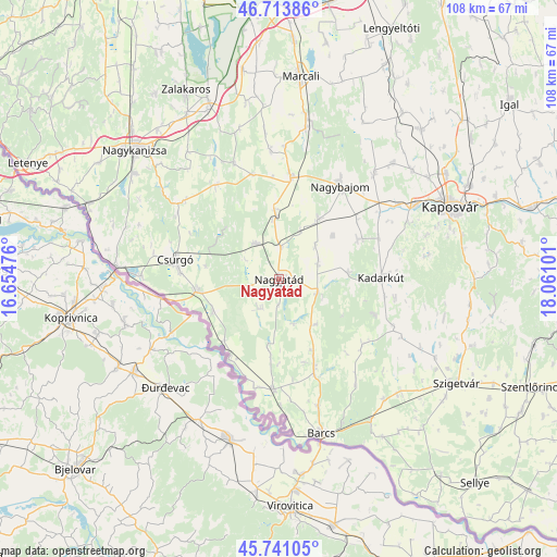
Nagyatád GPS coordinates[2]
46° 13' 46.596" North, 17° 21' 28.368" East
| Map corner | latitude | longitude |
|---|---|---|
| Upper-left | 46.71386°, | 16.65476° |
| Center: | 46.22961°, | 17.35788° |
| Lower-right: | 45.74105°, | 18.06101° |
| Map W x H: | 108.2×108.2 km | = 67.2×67.2mi |
| max Lat: | 48.46667° ⇑94.5% North |
| Nagyatád: | 46.22961° |
| min Lat: | ⇓5.5% South 45.79108° |
| min Long | Nagyatád | max Long |
| 16.27358° | 17.35788° | 22.68096° |
| W 6.7%⇐ | ⇒93.3% E |
Elevation
Elevation of Nagyatád is 133 m = 436 ft, and this is 3.3 m = 11 ft above average elevation for this country.
| Max E: |
444 m = 1457 ft | 33.1% |
| Nagyatád | 133 m 436 ft | |
| Avg. | 129.7 m = 426 ft | |
Min E: |
71 m = 233 ft | 66.9% |
See also: Hungary elevation on elevation.city.
Geographical zone
Nagyatád is located in North temperate zone (between Tropic of Cancer and the Arctic Circle). Distance of this North polar circle is 2260.9 km =1404.9 mi to North.| Distance of | km | miles | from Nagyatád |
|---|---|---|---|
| North Pole | 4866.8 | 3024.1 | to North |
| Arctic Circle | 2260.9 | 1404.9 | to North |
| Tropic Cancer | 2534.3 | 1574.7 | to South |
| Equator | 5140.3 | 3194 | to South |


Nearby cities:
15 places around Nagyatád: (largest is in red/bold)
• Babócsa
20.9 km =13 mi,  183°
183°
• Barcs
31 km =19.3 mi,  165°
165°
• Berzence
16.3 km =10.1 mi,  261°
261°
• Böhönye
20.5 km =12.7 mi,  4°
4°
• Csurgó
20 km =12.4 mi,  277°
277°
• Kadarkút
20.2 km =12.6 mi,  87°
87°
• Kaposmérő
30.4 km =18.9 mi,  61°
61°
• Kaposvár
37.2 km =23.1 mi,  65°
65°
• Lábod
7.9 km =4.9 mi,  110°
110°
• Nagybajom
21.6 km =13.4 mi,  33°
33°
• Nagydobsza
32.3 km =20.1 mi,  132°
132°
• Nagykanizsa
37.6 km =23.4 mi,  311°
311°
• Segesd
12.4 km =7.7 mi,  357°
357°
• Zalakomár
36.9 km =22.9 mi,  338°
338°
• Ötvöskónyi
6.4 km =4 mi, 1°
Sources, notices
• [Note1] Compared only with cities in Hungary existing in our database
• [Src1] Map data: © OpenStreetMap contributors (CC-BY-SA)
• [Src2] Other city data from geonames.org with taken over terms of usage.
• [Src3] Geographical zone / Annual Mean Temperature by Robert A. Rohde @ Wikipedia
