Böhönye geodata
Böhönye (Somogy) is a populated place; located in Hungary in Europe/Budapest (GMT+2) time zone. With population of 2,437 people, there are 635 cities with bigger population in this country. Compared to other cities in Hungary, 88.7% of cities are located further ↑North; 93% of cities are located further →East and 81.7% of cities have lower elevation than Böhönye. Note1


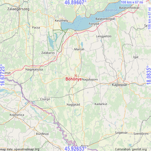
Böhönye GPS coordinates[2]
46° 24' 48.42" North, 17° 22' 49.332" East
| Map corner | latitude | longitude |
|---|---|---|
| Upper-left | 46.89607°, | 16.67725° |
| Center: | 46.41345°, | 17.38037° |
| Lower-right: | 45.92653°, | 18.0835° |
| Map W x H: | 107.8×107.8 km | = 67×67mi |
| max Lat: | 48.46667° ⇑88.7% North |
| Böhönye: | 46.41345° |
| min Lat: | ⇓11.3% South 45.79108° |
| min Long | Böhönye | max Long |
| 16.27358° | 17.38037° | 22.68096° |
| W 7%⇐ | ⇒93% E |
Elevation
Elevation of Böhönye is 162 m = 531 ft, and this is 32.3 m = 106 ft above average elevation for this country.
| Max E: |
444 m = 1457 ft | 18.3% |
| Böhönye | 162 m 531 ft | |
| Avg. | 129.7 m = 426 ft | |
Min E: |
71 m = 233 ft | 81.7% |
See also: Hungary elevation on elevation.city.
Geographical zone
Böhönye is located in North temperate zone (between Tropic of Cancer and the Arctic Circle). Distance of this North polar circle is 2240.5 km =1392.2 mi to North.| Distance of | km | miles | from Böhönye |
|---|---|---|---|
| North Pole | 4846.4 | 3011.4 | to North |
| Arctic Circle | 2240.5 | 1392.2 | to North |
| Tropic Cancer | 2554.8 | 1587.5 | to South |
| Equator | 5160.7 | 3206.7 | to South |


Nearby cities:
15 places around Böhönye: (largest is in red/bold)
• Berzence
28.9 km =18 mi,  218°
218°
• Csurgó
27.9 km =17.3 mi,  230°
230°
• Kadarkút
27 km =16.8 mi,  136°
136°
• Kaposmérő
25.5 km =15.8 mi,  103°
103°
• Kaposvár
32.6 km =20.3 mi, 99°
• Kéthely
25.9 km =16.1 mi,  2°
2°
• Lábod
23.8 km =14.8 mi,  166°
166°
• Marcali
19.2 km =11.9 mi,  7°
7°
• Nagyatád
20.5 km =12.7 mi,  184°
184°
• Nagybajom
10.3 km =6.4 mi, 103°
• Nagykanizsa
30.2 km =18.8 mi,  278°
278°
• Segesd
8.3 km =5.2 mi,  195°
195°
• Somogyvár
28.6 km =17.8 mi,  49°
49°
• Zalakomár
20.6 km =12.8 mi,  312°
312°
• Ötvöskónyi
14.1 km =8.8 mi,  186°
186°
Sources, notices
• [Note1] Compared only with cities in Hungary existing in our database
• [Src1] Map data: © OpenStreetMap contributors (CC-BY-SA)
• [Src2] Other city data from geonames.org with taken over terms of usage.
• [Src3] Geographical zone / Annual Mean Temperature by Robert A. Rohde @ Wikipedia
