Berzence geodata
Berzence (Somogy) is a populated place; located in Hungary in Europe/Budapest (GMT+2) time zone. With population of 2,694 people, there are 571 cities with bigger population in this country. Compared to other cities in Hungary, 95.2% of cities are located further ↑North; 96% of cities are located further →East and 60.4% of cities have lower elevation than Berzence. Note1


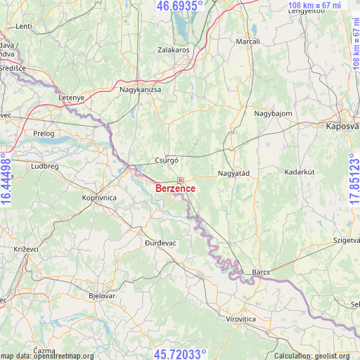
Berzence GPS coordinates[2]
46° 12' 32.652" North, 17° 8' 53.16" East
| Map corner | latitude | longitude |
|---|---|---|
| Upper-left | 46.6935°, | 16.44498° |
| Center: | 46.20907°, | 17.1481° |
| Lower-right: | 45.72033°, | 17.85123° |
| Map W x H: | 108.2×108.2 km | = 67.2×67.2mi |
| max Lat: | 48.46667° ⇑95.2% North |
| Berzence: | 46.20907° |
| min Lat: | ⇓4.8% South 45.79108° |
| min Long | Berzence | max Long |
| 16.27358° | 17.1481° | 22.68096° |
| W 4%⇐ | ⇒96% E |
Elevation
Elevation of Berzence is 126 m = 413 ft, and this is 3.7 m = 12 ft below average elevation for this country.
| Max E: |
444 m = 1457 ft | 39.6% |
| Avg. | 129.7 m = 426 ft | |
| Berzence | 126 m = 413 ft | |
Min E: |
71 m = 233 ft | 60.4% |
See also: Hungary elevation on elevation.city.
Geographical zone
Berzence is located in North temperate zone (between Tropic of Cancer and the Arctic Circle). Distance of this North polar circle is 2263.2 km =1406.3 mi to North.| Distance of | km | miles | from Berzence |
|---|---|---|---|
| North Pole | 4869.1 | 3025.5 | to North |
| Arctic Circle | 2263.2 | 1406.3 | to North |
| Tropic Cancer | 2532 | 1573.3 | to South |
| Equator | 5138 | 3192.6 | to South |


Nearby cities:
15 places around Berzence: (largest is in red/bold)
• Babócsa
23.9 km =14.9 mi,  141°
141°
• Barcs
36.6 km =22.7 mi, 139°
• Becsehely
38.9 km =24.2 mi,  312°
312°
• Böhönye
28.9 km =18 mi,  38°
38°
• Csurgó
6.1 km =3.8 mi,  323°
323°
• Kadarkút
36.4 km =22.6 mi,  85°
85°
• Letenye
40.9 km =25.4 mi, 307°
• Lábod
23.6 km =14.7 mi, 91°
• Murakeresztúr
26.8 km =16.7 mi, 310°
• Nagyatád
16.3 km =10.1 mi,  81°
81°
• Nagybajom
34.6 km =21.5 mi,  53°
53°
• Nagykanizsa
29.7 km =18.5 mi,  336°
336°
• Segesd
21.5 km =13.4 mi, 46°
• Zalakomár
36.7 km =22.8 mi,  3°
3°
• Ötvöskónyi
18.5 km =11.5 mi,  61°
61°
Sources, notices
• [Note1] Compared only with cities in Hungary existing in our database
• [Src1] Map data: © OpenStreetMap contributors (CC-BY-SA)
• [Src2] Other city data from geonames.org with taken over terms of usage.
• [Src3] Geographical zone / Annual Mean Temperature by Robert A. Rohde @ Wikipedia
