Kaposvár geodata
Kaposvár (Somogy) is a seat of a first-order administrative division; located in Hungary in Europe/Budapest (GMT+2) time zone. With population of 67,746 people, there are 27 cities with bigger population in this country. Compared to other cities in Hungary, 89.8% of cities are located further ↑North; 88.5% of cities are located further →East and 73.5% of cities have lower elevation than Kaposvár. Note1


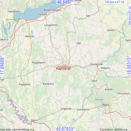
Kaposvár GPS coordinates[2]
46° 22' 0.012" North, 17° 48' 0" East
| Map corner | latitude | longitude |
|---|---|---|
| Upper-left | 46.8497°, | 17.09688° |
| Center: | 46.36667°, | 17.8° |
| Lower-right: | 45.87933°, | 18.50313° |
| Map W x H: | 107.9×107.9 km | = 67×67mi |
| max Lat: | 48.46667° ⇑89.8% North |
| Kaposvár: | 46.36667° |
| min Lat: | ⇓10.2% South 45.79108° |
| min Long | Kaposvár | max Long |
| 16.27358° | 17.8° | 22.68096° |
| W 11.5%⇐ | ⇒88.5% E |
Elevation
Elevation of Kaposvár is 144 m = 472 ft, and this is 14.3 m = 47 ft above average elevation for this country.
| Max E: |
444 m = 1457 ft | 26.5% |
| Kaposvár | 144 m 472 ft | |
| Avg. | 129.7 m = 426 ft | |
Min E: |
71 m = 233 ft | 73.5% |
See also: Kaposvár elevation on elevation.city.
Geographical zone
Kaposvár is located in North temperate zone (between Tropic of Cancer and the Arctic Circle). Distance of this North polar circle is 2245.7 km =1395.4 mi to North.| Distance of | km | miles | from Kaposvár |
|---|---|---|---|
| North Pole | 4851.6 | 3014.6 | to North |
| Arctic Circle | 2245.7 | 1395.4 | to North |
| Tropic Cancer | 2549.6 | 1584.2 | to South |
| Equator | 5155.5 | 3203.5 | to South |


Nearby cities:
15 places around Kaposvár: (largest is in red/bold)
• Böhönye
32.6 km =20.3 mi,  279°
279°
• Bükkösd
32.2 km =20 mi,  153°
153°
• Dombóvár
25.9 km =16.1 mi,  87°
87°
• Döbrököz
34.3 km =21.3 mi,  79°
79°
• Gödre
16 km =9.9 mi,  124°
124°
• Kadarkút
20 km =12.4 mi,  223°
223°
• Kaposmérő
7.4 km =4.6 mi,  265°
265°
• Lábod
32.1 km =19.9 mi,  235°
235°
• Mágocs
33.2 km =20.6 mi, 93°
• Nagybajom
22.3 km =13.9 mi, 277°
• Segesd
34.5 km =21.4 mi, 265°
• Somogyvár
26.1 km =16.2 mi,  336°
336°
• Szakcs
30.5 km =19 mi,  51°
51°
• Sásd
26.7 km =16.6 mi, 117°
• Taszár
8.2 km =5.1 mi, 83°
Sources, notices
• [Note1] Compared only with cities in Hungary existing in our database
• [Src1] Map data: © OpenStreetMap contributors (CC-BY-SA)
• [Src2] Other city data from geonames.org with taken over terms of usage.
• [Src3] Geographical zone / Annual Mean Temperature by Robert A. Rohde @ Wikipedia
