Kéthely geodata
Kéthely (Somogy) is a populated place; located in Hungary in Europe/Budapest (GMT+2) time zone. With population of 2,408 people, there are 639 cities with bigger population in this country. Compared to other cities in Hungary, 81.9% of cities are located further ↑North; 92.7% of cities are located further →East and 55.3% of cities have lower elevation than Kéthely. Note1


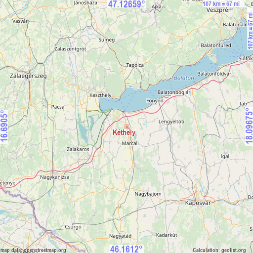
Kéthely GPS coordinates[2]
46° 38' 45.78" North, 17° 23' 37.032" East
| Map corner | latitude | longitude |
|---|---|---|
| Upper-left | 47.12659°, | 16.6905° |
| Center: | 46.64605°, | 17.39362° |
| Lower-right: | 46.1612°, | 18.09675° |
| Map W x H: | 107.3×107.3 km | = 66.7×66.7mi |
| max Lat: | 48.46667° ⇑81.9% North |
| Kéthely: | 46.64605° |
| min Lat: | ⇓18.1% South 45.79108° |
| min Long | Kéthely | max Long |
| 16.27358° | 17.39362° | 22.68096° |
| W 7.3%⇐ | ⇒92.7% E |
Elevation
Elevation of Kéthely is 121 m = 397 ft, and this is 8.7 m = 29 ft below average elevation for this country.
| Max E: |
444 m = 1457 ft | 44.7% |
| Avg. | 129.7 m = 426 ft | |
| Kéthely | 121 m = 397 ft | |
Min E: |
71 m = 233 ft | 55.3% |
See also: Hungary elevation on elevation.city.
Geographical zone
Kéthely is located in North temperate zone (between Tropic of Cancer and the Arctic Circle). Distance of this North polar circle is 2214.6 km =1376.1 mi to North.| Distance of | km | miles | from Kéthely |
|---|---|---|---|
| North Pole | 4820.5 | 2995.3 | to North |
| Arctic Circle | 2214.6 | 1376.1 | to North |
| Tropic Cancer | 2580.6 | 1603.5 | to South |
| Equator | 5186.6 | 3222.8 | to South |


Nearby cities:
15 places around Kéthely: (largest is in red/bold)
• Badacsonytomaj
20.1 km =12.5 mi,  27°
27°
• Balatonberény
8.8 km =5.5 mi,  320°
320°
• Balatonboglár
23.9 km =14.9 mi,  53°
53°
• Balatonfenyves
10.8 km =6.7 mi,  44°
44°
• Cserszegtomaj
21.7 km =13.5 mi, 322°
• Fonyód
18.7 km =11.6 mi, 49°
• Gyenesdiás
16.1 km =10 mi,  329°
329°
• Hévíz
22.6 km =14 mi, 315°
• Keszthely
17.8 km =11.1 mi, 319°
• Lengyeltóti
19.3 km =12 mi,  82°
82°
• Marcali
6.9 km =4.3 mi,  168°
168°
• Somogyvár
21.8 km =13.5 mi,  109°
109°
• Sármellék
18.7 km =11.6 mi,  293°
293°
• Vonyarcvashegy
13.9 km =8.6 mi, 333°
• Zalakomár
20.2 km =12.6 mi,  233°
233°
Sources, notices
• [Note1] Compared only with cities in Hungary existing in our database
• [Src1] Map data: © OpenStreetMap contributors (CC-BY-SA)
• [Src2] Other city data from geonames.org with taken over terms of usage.
• [Src3] Geographical zone / Annual Mean Temperature by Robert A. Rohde @ Wikipedia
