Nagykanizsa geodata
Nagykanizsa (Zala) is a populated place; located in Hungary in Europe/Budapest (GMT+2) time zone. With population of 50,823 people, there are 39 cities with bigger population in this country. Compared to other cities in Hungary, 87% of cities are located further ↑North; 97.2% of cities are located further →East and 77.7% of cities have lower elevation than Nagykanizsa. Note1


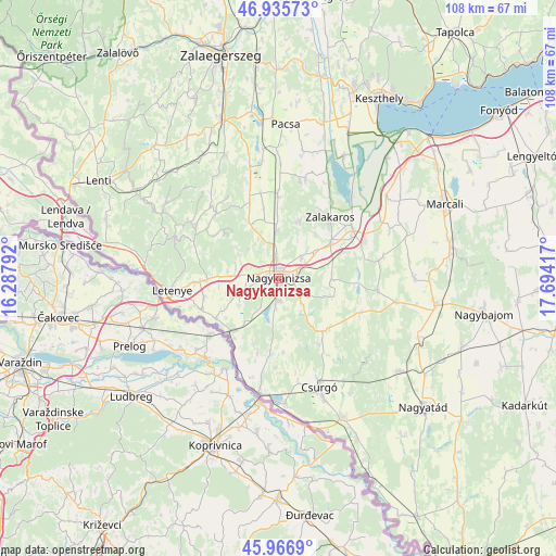
Nagykanizsa GPS coordinates[2]
46° 27' 12.492" North, 16° 59' 27.744" East
| Map corner | latitude | longitude |
|---|---|---|
| Upper-left | 46.93573°, | 16.28792° |
| Center: | 46.45347°, | 16.99104° |
| Lower-right: | 45.9669°, | 17.69417° |
| Map W x H: | 107.7×107.7 km | = 66.9×66.9mi |
| max Lat: | 48.46667° ⇑87% North |
| Nagykanizsa: | 46.45347° |
| min Lat: | ⇓13% South 45.79108° |
| min Long | Nagykanizsa | max Long |
| 16.27358° | 16.99104° | 22.68096° |
| W 2.8%⇐ | ⇒97.2% E |
Elevation
Elevation of Nagykanizsa is 152 m = 499 ft, and this is 22.3 m = 73 ft above average elevation for this country.
| Max E: |
444 m = 1457 ft | 22.3% |
| Nagykanizsa | 152 m 499 ft | |
| Avg. | 129.7 m = 426 ft | |
Min E: |
71 m = 233 ft | 77.7% |
See also: Nagykanizsa elevation on elevation.city.
Geographical zone
Nagykanizsa is located in North temperate zone (between Tropic of Cancer and the Arctic Circle). Distance of this North polar circle is 2236 km =1389.4 mi to North.| Distance of | km | miles | from Nagykanizsa |
|---|---|---|---|
| North Pole | 4841.9 | 3008.6 | to North |
| Arctic Circle | 2236 | 1389.4 | to North |
| Tropic Cancer | 2559.2 | 1590.2 | to South |
| Equator | 5165.1 | 3209.4 | to South |


Nearby cities:
15 places around Nagykanizsa: (largest is in red/bold)
• Balatonberény
37.8 km =23.5 mi,  41°
41°
• Becsehely
16.4 km =10.2 mi,  267°
267°
• Berzence
29.7 km =18.5 mi,  156°
156°
• Böhönye
30.2 km =18.8 mi,  98°
98°
• Csurgó
23.8 km =14.8 mi, 159°
• Kéthely
37.5 km =23.3 mi,  55°
55°
• Letenye
20.4 km =12.7 mi,  263°
263°
• Marcali
35.4 km =22 mi,  65°
65°
• Murakeresztúr
13 km =8.1 mi,  220°
220°
• Nagyatád
37.6 km =23.4 mi,  131°
131°
• Pacsa
29.7 km =18.5 mi,  3°
3°
• Segesd
30.3 km =18.8 mi,  114°
114°
• Sármellék
31.8 km =19.8 mi,  25°
25°
• Zalakomár
17.3 km =10.7 mi, 57°
• Ötvöskónyi
33.8 km =21 mi,  123°
123°
Sources, notices
• [Note1] Compared only with cities in Hungary existing in our database
• [Src1] Map data: © OpenStreetMap contributors (CC-BY-SA)
• [Src2] Other city data from geonames.org with taken over terms of usage.
• [Src3] Geographical zone / Annual Mean Temperature by Robert A. Rohde @ Wikipedia
