Bábolna geodata
Bábolna (Komárom-Esztergom) is a populated place; located in Hungary in Europe/Budapest (GMT+2) time zone. With population of 3,885 people, there are 385 cities with bigger population in this country. Compared to other cities in Hungary, 66.2% of cities are located further ↓South; 86.4% of cities are located further →East and 67.7% of cities have lower elevation than Bábolna. Note1


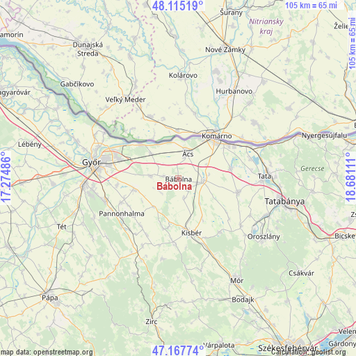
Bábolna GPS coordinates[2]
47° 38' 36.996" North, 17° 58' 40.728" East
| Map corner | latitude | longitude |
|---|---|---|
| Upper-left | 48.11519°, | 17.27486° |
| Center: | 47.64361°, | 17.97798° |
| Lower-right: | 47.16774°, | 18.68111° |
| Map W x H: | 105.3×105.3 km | = 65.4×65.4mi |
| max Lat: | 48.46667° ⇑33.8% North |
| Bábolna: | 47.64361° |
| min Lat: | ⇓66.2% South 45.79108° |
| min Long | Bábolna | max Long |
| 16.27358° | 17.97798° | 22.68096° |
| W 13.6%⇐ | ⇒86.4% E |
Elevation
Elevation of Bábolna is 134 m = 440 ft, and this is 4.3 m = 14 ft above average elevation for this country.
| Max E: |
444 m = 1457 ft | 32.3% |
| Bábolna | 134 m 440 ft | |
| Avg. | 129.7 m = 426 ft | |
Min E: |
71 m = 233 ft | 67.7% |
See also: Hungary elevation on elevation.city.
Geographical zone
Bábolna is located in North temperate zone (between Tropic of Cancer and the Arctic Circle). Distance of this North polar circle is 2103.7 km =1307.2 mi to North.| Distance of | km | miles | from Bábolna |
|---|---|---|---|
| North Pole | 4709.6 | 2926.4 | to North |
| Arctic Circle | 2103.7 | 1307.2 | to North |
| Tropic Cancer | 2691.6 | 1672.5 | to South |
| Equator | 5297.5 | 3291.7 | to South |


Nearby cities:
15 places around Bábolna: (largest is in red/bold)
• Almásfüzitő
23.2 km =14.4 mi,  66°
66°
• Bőny
8.1 km =5 mi,  275°
275°
• Császár
20.4 km =12.7 mi,  142°
142°
• Ete
14.5 km =9 mi,  149°
149°
• Kisbér
16.3 km =10.1 mi,  164°
164°
• Kocs
18.2 km =11.3 mi,  102°
102°
• Komárom
15.3 km =9.5 mi,  43°
43°
• Mocsa
15.8 km =9.8 mi,  79°
79°
• Nagyigmánd
7.7 km =4.8 mi,  92°
92°
• Naszály
22 km =13.7 mi, 72°
• Nyúl
22.4 km =13.9 mi,  254°
254°
• Pannonhalma
19.7 km =12.2 mi,  237°
237°
• Pér
13.3 km =8.3 mi, 254°
• Töltéstava
18.4 km =11.4 mi,  263°
263°
• Ács
8 km =5 mi,  18°
18°
Sources, notices
• [Note1] Compared only with cities in Hungary existing in our database
• [Src1] Map data: © OpenStreetMap contributors (CC-BY-SA)
• [Src2] Other city data from geonames.org with taken over terms of usage.
• [Src3] Geographical zone / Annual Mean Temperature by Robert A. Rohde @ Wikipedia
