Kisbér geodata
Kisbér (Komárom-Esztergom) is a seat of a second-order administrative division; located in Hungary in Europe/Budapest (GMT+2) time zone. With population of 5,850 people, there are 261 cities with bigger population in this country. Compared to other cities in Hungary, 55.9% of cities are located further ↓South; 85.2% of cities are located further →East and 86.5% of cities have lower elevation than Kisbér. Note1


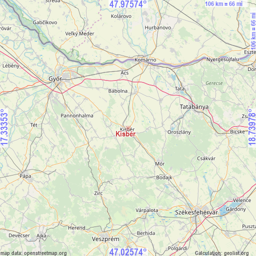
Kisbér GPS coordinates[2]
47° 30' 10.404" North, 18° 2' 11.94" East
| Map corner | latitude | longitude |
|---|---|---|
| Upper-left | 47.97574°, | 17.33353° |
| Center: | 47.50289°, | 18.03665° |
| Lower-right: | 47.02574°, | 18.73978° |
| Map W x H: | 105.6×105.6 km | = 65.6×65.6mi |
| max Lat: | 48.46667° ⇑44.1% North |
| Kisbér: | 47.50289° |
| min Lat: | ⇓55.9% South 45.79108° |
| min Long | Kisbér | max Long |
| 16.27358° | 18.03665° | 22.68096° |
| W 14.8%⇐ | ⇒85.2% E |
Elevation
Elevation of Kisbér is 177 m = 581 ft, and this is 47.3 m = 155 ft above average elevation for this country.
| Max E: |
444 m = 1457 ft | 13.5% |
| Kisbér | 177 m 581 ft | |
| Avg. | 129.7 m = 426 ft | |
Min E: |
71 m = 233 ft | 86.5% |
See also: Hungary elevation on elevation.city.
Geographical zone
Kisbér is located in North temperate zone (between Tropic of Cancer and the Arctic Circle). Distance of this North polar circle is 2119.3 km =1316.9 mi to North.| Distance of | km | miles | from Kisbér |
|---|---|---|---|
| North Pole | 4725.2 | 2936.1 | to North |
| Arctic Circle | 2119.3 | 1316.9 | to North |
| Tropic Cancer | 2675.9 | 1662.7 | to South |
| Equator | 5281.8 | 3282 | to South |


Nearby cities:
15 places around Kisbér: (largest is in red/bold)
• Bakonycsernye
20.1 km =12.5 mi,  171°
171°
• Bakonyszentlászló
21.6 km =13.4 mi,  234°
234°
• Bokod
15.9 km =9.9 mi,  94°
94°
• Bábolna
16.3 km =10.1 mi,  344°
344°
• Bőny
20.6 km =12.8 mi,  322°
322°
• Csetény
20.8 km =12.9 mi,  189°
189°
• Császár
8 km =5 mi, 93°
• Ete
4.2 km =2.6 mi,  43°
43°
• Kecskéd
20.6 km =12.8 mi,  83°
83°
• Kocs
17.7 km =11 mi,  49°
49°
• Mór
18.7 km =11.6 mi,  137°
137°
• Nagyigmánd
15.7 km =9.8 mi,  12°
12°
• Oroszlány
20.8 km =12.9 mi, 94°
• Pusztavám
16.4 km =10.2 mi,  119°
119°
• Pér
21.1 km =13.1 mi,  304°
304°
Sources, notices
• [Note1] Compared only with cities in Hungary existing in our database
• [Src1] Map data: © OpenStreetMap contributors (CC-BY-SA)
• [Src2] Other city data from geonames.org with taken over terms of usage.
• [Src3] Geographical zone / Annual Mean Temperature by Robert A. Rohde @ Wikipedia
