Ács geodata
Ács (Komárom-Esztergom) is a populated place; located in Hungary in Europe/Budapest (GMT+2) time zone. With population of 7,180 people, there are 213 cities with bigger population in this country. Compared to other cities in Hungary, 71.4% of cities are located further ↓South; 85.7% of cities are located further →East and 50.7% of cities have lower elevation than Ács. Note1


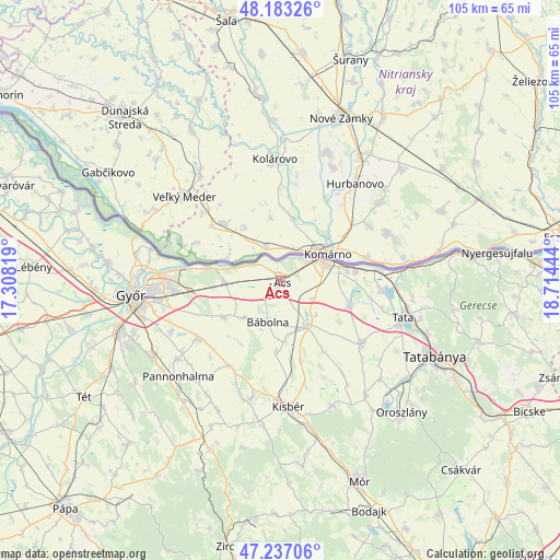
Ács GPS coordinates[2]
47° 42' 44.316" North, 18° 0' 40.716" East
| Map corner | latitude | longitude |
|---|---|---|
| Upper-left | 48.18326°, | 17.30819° |
| Center: | 47.71231°, | 18.01131° |
| Lower-right: | 47.23706°, | 18.71444° |
| Map W x H: | 105.2×105.2 km | = 65.4×65.4mi |
| max Lat: | 48.46667° ⇑28.6% North |
| Ács: | 47.71231° |
| min Lat: | ⇓71.4% South 45.79108° |
| min Long | Ács | max Long |
| 16.27358° | 18.01131° | 22.68096° |
| W 14.3%⇐ | ⇒85.7% E |
Elevation
Elevation of Ács is 116 m = 381 ft, and this is 13.7 m = 45 ft below average elevation for this country.
| Max E: |
444 m = 1457 ft | 49.3% |
| Avg. | 129.7 m = 426 ft | |
| Ács | 116 m = 381 ft | |
Min E: |
71 m = 233 ft | 50.7% |
See also: Hungary elevation on elevation.city.
Geographical zone
Ács is located in North temperate zone (between Tropic of Cancer and the Arctic Circle). Distance of this North polar circle is 2096.1 km =1302.5 mi to North.| Distance of | km | miles | from Ács |
|---|---|---|---|
| North Pole | 4702 | 2921.7 | to North |
| Arctic Circle | 2096.1 | 1302.5 | to North |
| Tropic Cancer | 2699.2 | 1677.2 | to South |
| Equator | 5305.1 | 3296.4 | to South |


Nearby cities:
15 places around Ács: (largest is in red/bold)
• Almásfüzitő
18.8 km =11.7 mi,  84°
84°
• Bábolna
8 km =5 mi,  198°
198°
• Bőny
12.7 km =7.9 mi,  236°
236°
• Dunaalmás
23.3 km =14.5 mi,  85°
85°
• Ete
20.7 km =12.9 mi,  166°
166°
• Kisbér
23.4 km =14.5 mi,  175°
175°
• Kocs
19.2 km =11.9 mi,  127°
127°
• Komárom
8.8 km =5.5 mi,  66°
66°
• Mocsa
13.8 km =8.6 mi,  109°
109°
• Nagyigmánd
9.5 km =5.9 mi,  146°
146°
• Naszály
18.4 km =11.4 mi, 93°
• Pér
19 km =11.8 mi,  233°
233°
• Szomód
24.8 km =15.4 mi,  97°
97°
• Tata
23.9 km =14.9 mi, 106°
• Töltéstava
22.9 km =14.2 mi,  245°
245°
Sources, notices
• [Note1] Compared only with cities in Hungary existing in our database
• [Src1] Map data: © OpenStreetMap contributors (CC-BY-SA)
• [Src2] Other city data from geonames.org with taken over terms of usage.
• [Src3] Geographical zone / Annual Mean Temperature by Robert A. Rohde @ Wikipedia
