Szob geodata
Szob (Pest) is a seat of a second-order administrative division; located in Hungary in Europe/Budapest (GMT+2) time zone. With population of 3,065 people, there are 483 cities with bigger population in this country. Compared to other cities in Hungary, 79% of cities are located further ↓South; 69.1% of cities are located further →East and 58.1% of cities have higher elevation than Szob. Note1


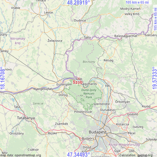
Szob GPS coordinates[2]
47° 49' 9.156" North, 18° 52' 12.72" East
| Map corner | latitude | longitude |
|---|---|---|
| Upper-left | 48.28919°, | 18.16708° |
| Center: | 47.81921°, | 18.8702° |
| Lower-right: | 47.34493°, | 19.57333° |
| Map W x H: | 105×105 km | = 65.2×65.2mi |
| max Lat: | 48.46667° ⇑21% North |
| Szob: | 47.81921° |
| min Lat: | ⇓79% South 45.79108° |
| min Long | Szob | max Long |
| 16.27358° | 18.8702° | 22.68096° |
| W 30.9%⇐ | ⇒69.1% E |
Elevation
Elevation of Szob is 111 m = 364 ft, and this is 18.7 m = 61 ft below average elevation for this country.
| Max E: |
444 m = 1457 ft | 58.1% |
| Avg. | 129.7 m = 426 ft | |
| Szob | 111 m = 364 ft | |
Min E: |
71 m = 233 ft | 41.9% |
See also: Hungary elevation on elevation.city.
Geographical zone
Szob is located in North temperate zone (between Tropic of Cancer and the Arctic Circle). Distance of this North polar circle is 2084.2 km =1295.1 mi to North.| Distance of | km | miles | from Szob |
|---|---|---|---|
| North Pole | 4690.1 | 2914.3 | to North |
| Arctic Circle | 2084.2 | 1295.1 | to North |
| Tropic Cancer | 2711.1 | 1684.6 | to South |
| Equator | 5317 | 3303.8 | to South |


Nearby cities:
15 places around Szob: (largest is in red/bold)
• Csolnok
18.3 km =11.4 mi,  218°
218°
• Diósjenő
18.6 km =11.6 mi,  43°
43°
• Dorog
14.8 km =9.2 mi, 222°
• Dunabogdány
13.2 km =8.2 mi,  104°
104°
• Esztergom
10.1 km =6.3 mi,  253°
253°
• Kesztölc
12.9 km =8 mi,  203°
203°
• Kismaros
10.2 km =6.3 mi,  78°
78°
• Nagymaros
7.3 km =4.5 mi,  113°
113°
• Piliscsév
16 km =9.9 mi,  193°
193°
• Pilismarót
3.9 km =2.4 mi,  174°
174°
• Pilisszentkereszt
14.4 km =8.9 mi, 169°
• Pilisszántó
16.7 km =10.4 mi,  175°
175°
• Tát
18.7 km =11.6 mi,  242°
242°
• Verőce
12.3 km =7.6 mi,  87°
87°
• Visegrád
8.4 km =5.2 mi,  116°
116°
Sources, notices
• [Note1] Compared only with cities in Hungary existing in our database
• [Src1] Map data: © OpenStreetMap contributors (CC-BY-SA)
• [Src2] Other city data from geonames.org with taken over terms of usage.
• [Src3] Geographical zone / Annual Mean Temperature by Robert A. Rohde @ Wikipedia
