Lenti geodata
Lenti (Zala) is a seat of a second-order administrative division; located in Hungary in Europe/Budapest (GMT+2) time zone. With population of 8,399 people, there are 190 cities with bigger population in this country. Compared to other cities in Hungary, 82.6% of cities are located further ↑North; 99.8% of cities are located further →East and 83.4% of cities have lower elevation than Lenti. Note1


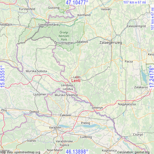
Lenti GPS coordinates[2]
46° 37' 26.508" North, 16° 32' 19.068" East
| Map corner | latitude | longitude |
|---|---|---|
| Upper-left | 47.10477°, | 15.83551° |
| Center: | 46.62403°, | 16.53863° |
| Lower-right: | 46.13898°, | 17.24176° |
| Map W x H: | 107.4×107.4 km | = 66.7×66.7mi |
| max Lat: | 48.46667° ⇑82.6% North |
| Lenti: | 46.62403° |
| min Lat: | ⇓17.4% South 45.79108° |
| min Long | Lenti | max Long |
| 16.27358° | 16.53863° | 22.68096° |
| W 0.2%⇐ | ⇒99.8% E |
Elevation
Elevation of Lenti is 168 m = 551 ft, and this is 38.3 m = 126 ft above average elevation for this country.
| Max E: |
444 m = 1457 ft | 16.6% |
| Lenti | 168 m 551 ft | |
| Avg. | 129.7 m = 426 ft | |
Min E: |
71 m = 233 ft | 83.4% |
See also: Hungary elevation on elevation.city.
Geographical zone
Lenti is located in North temperate zone (between Tropic of Cancer and the Arctic Circle). Distance of this North polar circle is 2217.1 km =1377.6 mi to North.| Distance of | km | miles | from Lenti |
|---|---|---|---|
| North Pole | 4823 | 2996.9 | to North |
| Arctic Circle | 2217.1 | 1377.6 | to North |
| Tropic Cancer | 2578.2 | 1602 | to South |
| Equator | 5184.1 | 3221.2 | to South |


Nearby cities:
15 places around Lenti: (largest is in red/bold)
• Becsehely
26.8 km =16.7 mi,  137°
137°
• Hévíz
52.6 km =32.7 mi,  69°
69°
• Körmend
43.3 km =26.9 mi,  6°
6°
• Letenye
25.6 km =15.9 mi,  146°
146°
• Murakeresztúr
39 km =24.2 mi, 137°
• Nagykanizsa
39.5 km =24.5 mi,  118°
118°
• Nemesbük
51.3 km =31.9 mi, 65°
• Pacsa
37.8 km =23.5 mi, 73°
• Szentgotthárd
41.7 km =25.9 mi,  331°
331°
• Sármellék
49.1 km =30.5 mi,  78°
78°
• Vasvár
51.3 km =31.9 mi,  22°
22°
• Zalaegerszeg
33.4 km =20.8 mi,  44°
44°
• Zalakomár
50 km =31.1 mi,  101°
101°
• Zalalövő
25.2 km =15.7 mi, 8°
• Zalaszentgrót
54.5 km =33.9 mi,  49°
49°
Sources, notices
• [Note1] Compared only with cities in Hungary existing in our database
• [Src1] Map data: © OpenStreetMap contributors (CC-BY-SA)
• [Src2] Other city data from geonames.org with taken over terms of usage.
• [Src3] Geographical zone / Annual Mean Temperature by Robert A. Rohde @ Wikipedia
