Sármellék geodata
Sármellék (Zala) is a populated place; located in Hungary in Europe/Budapest (GMT+2) time zone. With population of 1,836 people, there are 845 cities with bigger population in this country. Compared to other cities in Hungary, 80% of cities are located further ↑North; 95.5% of cities are located further →East and 56.8% of cities have lower elevation than Sármellék. Note1


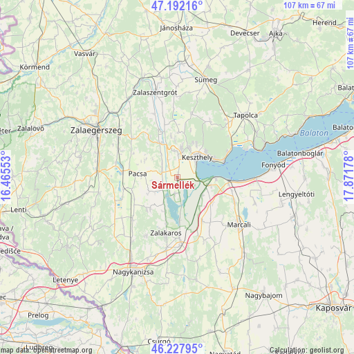
Sármellék GPS coordinates[2]
46° 42' 43.956" North, 17° 10' 7.14" East
| Map corner | latitude | longitude |
|---|---|---|
| Upper-left | 47.19216°, | 16.46553° |
| Center: | 46.71221°, | 17.16865° |
| Lower-right: | 46.22795°, | 17.87178° |
| Map W x H: | 107.2×107.2 km | = 66.6×66.6mi |
| max Lat: | 48.46667° ⇑80% North |
| Sármellék: | 46.71221° |
| min Lat: | ⇓20% South 45.79108° |
| min Long | Sármellék | max Long |
| 16.27358° | 17.16865° | 22.68096° |
| W 4.5%⇐ | ⇒95.5% E |
Elevation
Elevation of Sármellék is 123 m = 404 ft, and this is 6.7 m = 22 ft below average elevation for this country.
| Max E: |
444 m = 1457 ft | 43.2% |
| Avg. | 129.7 m = 426 ft | |
| Sármellék | 123 m = 404 ft | |
Min E: |
71 m = 233 ft | 56.8% |
See also: Hungary elevation on elevation.city.
Geographical zone
Sármellék is located in North temperate zone (between Tropic of Cancer and the Arctic Circle). Distance of this North polar circle is 2207.3 km =1371.6 mi to North.| Distance of | km | miles | from Sármellék |
|---|---|---|---|
| North Pole | 4813.2 | 2990.8 | to North |
| Arctic Circle | 2207.3 | 1371.6 | to North |
| Tropic Cancer | 2588 | 1608.1 | to South |
| Equator | 5193.9 | 3227.3 | to South |


Nearby cities:
15 places around Sármellék: (largest is in red/bold)
• Badacsonytomaj
28.3 km =17.6 mi,  68°
68°
• Balatonberény
11.6 km =7.2 mi,  92°
92°
• Balatonfenyves
24.7 km =15.3 mi, 89°
• Cserszegtomaj
10.7 km =6.6 mi,  21°
21°
• Gyenesdiás
11.1 km =6.9 mi,  54°
54°
• Hévíz
8.8 km =5.5 mi,  7°
7°
• Keszthely
8.4 km =5.2 mi,  42°
42°
• Kéthely
18.7 km =11.6 mi,  113°
113°
• Marcali
23.3 km =14.5 mi,  127°
127°
• Nemesbük
11.7 km =7.3 mi,  353°
353°
• Pacsa
11.8 km =7.3 mi,  274°
274°
• Tapolca
28 km =17.4 mi, 47°
• Vonyarcvashegy
12 km =7.5 mi, 65°
• Zalakomár
19.4 km =12.1 mi,  177°
177°
• Zalaszentgrót
26.7 km =16.6 mi, 345°
Sources, notices
• [Note1] Compared only with cities in Hungary existing in our database
• [Src1] Map data: © OpenStreetMap contributors (CC-BY-SA)
• [Src2] Other city data from geonames.org with taken over terms of usage.
• [Src3] Geographical zone / Annual Mean Temperature by Robert A. Rohde @ Wikipedia
