Letenye geodata
Letenye (Zala) is a seat of a second-order administrative division; located in Hungary in Europe/Budapest (GMT+2) time zone. With population of 4,527 people, there are 331 cities with bigger population in this country. Compared to other cities in Hungary, 87.7% of cities are located further ↑North; 98.3% of cities are located further →East and 75.8% of cities have lower elevation than Letenye. Note1


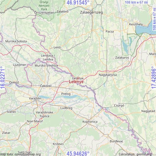
Letenye GPS coordinates[2]
46° 25' 58.836" North, 16° 43' 32.988" East
| Map corner | latitude | longitude |
|---|---|---|
| Upper-left | 46.91545°, | 16.02271° |
| Center: | 46.43301°, | 16.72583° |
| Lower-right: | 45.94626°, | 17.42896° |
| Map W x H: | 107.8×107.8 km | = 67×67mi |
| max Lat: | 48.46667° ⇑87.7% North |
| Letenye: | 46.43301° |
| min Lat: | ⇓12.3% South 45.79108° |
| min Long | Letenye | max Long |
| 16.27358° | 16.72583° | 22.68096° |
| W 1.7%⇐ | ⇒98.3% E |
Elevation
Elevation of Letenye is 148 m = 486 ft, and this is 18.3 m = 60 ft above average elevation for this country.
| Max E: |
444 m = 1457 ft | 24.2% |
| Letenye | 148 m 486 ft | |
| Avg. | 129.7 m = 426 ft | |
Min E: |
71 m = 233 ft | 75.8% |
See also: Hungary elevation on elevation.city.
Geographical zone
Letenye is located in North temperate zone (between Tropic of Cancer and the Arctic Circle). Distance of this North polar circle is 2238.3 km =1390.8 mi to North.| Distance of | km | miles | from Letenye |
|---|---|---|---|
| North Pole | 4844.2 | 3010 | to North |
| Arctic Circle | 2238.3 | 1390.8 | to North |
| Tropic Cancer | 2556.9 | 1588.8 | to South |
| Equator | 5162.9 | 3208.1 | to South |


Nearby cities:
15 places around Letenye: (largest is in red/bold)
• Becsehely
4.2 km =2.6 mi,  67°
67°
• Berzence
40.9 km =25.4 mi,  127°
127°
• Böhönye
50.2 km =31.2 mi,  92°
92°
• Csurgó
35 km =21.7 mi,  124°
124°
• Hévíz
52.9 km =32.9 mi,  41°
41°
• Lenti
25.6 km =15.9 mi,  326°
326°
• Murakeresztúr
14.2 km =8.8 mi, 122°
• Nagykanizsa
20.4 km =12.7 mi,  83°
83°
• Pacsa
38.8 km =24.1 mi,  34°
34°
• Segesd
49 km =30.4 mi,  101°
101°
• Sármellék
45.9 km =28.5 mi,  47°
47°
• Zalaegerszeg
46.1 km =28.6 mi,  11°
11°
• Zalakomár
36.7 km =22.8 mi, 71°
• Zalalövő
47.3 km =29.4 mi,  347°
347°
• Ötvöskónyi
51.3 km =31.9 mi,  108°
108°
Sources, notices
• [Note1] Compared only with cities in Hungary existing in our database
• [Src1] Map data: © OpenStreetMap contributors (CC-BY-SA)
• [Src2] Other city data from geonames.org with taken over terms of usage.
• [Src3] Geographical zone / Annual Mean Temperature by Robert A. Rohde @ Wikipedia
