Nagymányok geodata
Nagymányok (Tolna) is a populated place; located in Hungary in Europe/Budapest (GMT+2) time zone. With population of 2,504 people, there are 617 cities with bigger population in this country. Compared to other cities in Hungary, 93.1% of cities are located further ↑North; 77.6% of cities are located further →East and 66.2% of cities have lower elevation than Nagymányok. Note1


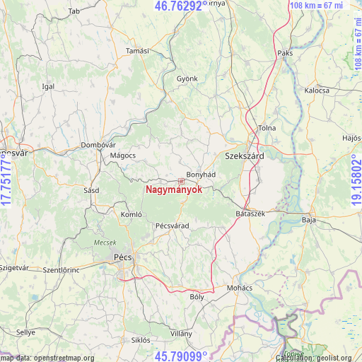
Nagymányok GPS coordinates[2]
46° 16' 44.796" North, 18° 27' 17.604" East
| Map corner | latitude | longitude |
|---|---|---|
| Upper-left | 46.76292°, | 17.75177° |
| Center: | 46.27911°, | 18.45489° |
| Lower-right: | 45.79099°, | 19.15802° |
| Map W x H: | 108.1×108.1 km | = 67.2×67.2mi |
| max Lat: | 48.46667° ⇑93.1% North |
| Nagymányok: | 46.27911° |
| min Lat: | ⇓6.9% South 45.79108° |
| min Long | Nagymányok | max Long |
| 16.27358° | 18.45489° | 22.68096° |
| W 22.4%⇐ | ⇒77.6% E |
Elevation
Elevation of Nagymányok is 132 m = 433 ft, and this is 2.3 m = 8 ft above average elevation for this country.
| Max E: |
444 m = 1457 ft | 33.8% |
| Nagymányok | 132 m 433 ft | |
| Avg. | 129.7 m = 426 ft | |
Min E: |
71 m = 233 ft | 66.2% |
See also: Hungary elevation on elevation.city.
Geographical zone
Nagymányok is located in North temperate zone (between Tropic of Cancer and the Arctic Circle). Distance of this North polar circle is 2255.4 km =1401.4 mi to North.| Distance of | km | miles | from Nagymányok |
|---|---|---|---|
| North Pole | 4861.3 | 3020.7 | to North |
| Arctic Circle | 2255.4 | 1401.4 | to North |
| Tropic Cancer | 2539.8 | 1578.2 | to South |
| Equator | 5145.8 | 3197.5 | to South |


Nearby cities:
15 places around Nagymányok: (largest is in red/bold)
• Bonyhád
6.2 km =3.9 mi,  68°
68°
• Bátaszék
22.7 km =14.1 mi,  114°
114°
• Decs
23.5 km =14.6 mi,  88°
88°
• Döbrököz
22.9 km =14.2 mi,  313°
313°
• Hidas
4 km =2.5 mi,  128°
128°
• Hosszúhetény
15.1 km =9.4 mi,  212°
212°
• Komló
17.5 km =10.9 mi,  236°
236°
• Mecseknádasd
6.2 km =3.9 mi,  168°
168°
• Mágocs
18.8 km =11.7 mi,  294°
294°
• Pécsvárad
13.4 km =8.3 mi,  190°
190°
• Szekszárd
21.1 km =13.1 mi, 67°
• Szentgálpuszta
16.9 km =10.5 mi,  51°
51°
• Szászvár
6.1 km =3.8 mi,  267°
267°
• Zomba
16.9 km =10.5 mi,  30°
30°
• Őcsény
23.6 km =14.7 mi,  80°
80°
Sources, notices
• [Note1] Compared only with cities in Hungary existing in our database
• [Src1] Map data: © OpenStreetMap contributors (CC-BY-SA)
• [Src2] Other city data from geonames.org with taken over terms of usage.
• [Src3] Geographical zone / Annual Mean Temperature by Robert A. Rohde @ Wikipedia
