Mágocs geodata
Mágocs (Baranya) is a populated place; located in Hungary in Europe/Budapest (GMT+2) time zone. With population of 2,652 people, there are 580 cities with bigger population in this country. Compared to other cities in Hungary, 90.7% of cities are located further ↑North; 82.7% of cities are located further →East and 84.5% of cities have lower elevation than Mágocs. Note1


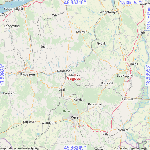
Mágocs GPS coordinates[2]
46° 20' 59.928" North, 18° 13' 56.64" East
| Map corner | latitude | longitude |
|---|---|---|
| Upper-left | 46.83316°, | 17.52928° |
| Center: | 46.34998°, | 18.2324° |
| Lower-right: | 45.86249°, | 18.93553° |
| Map W x H: | 107.9×107.9 km | = 67×67mi |
| max Lat: | 48.46667° ⇑90.7% North |
| Mágocs: | 46.34998° |
| min Lat: | ⇓9.3% South 45.79108° |
| min Long | Mágocs | max Long |
| 16.27358° | 18.2324° | 22.68096° |
| W 17.3%⇐ | ⇒82.7% E |
Elevation
Elevation of Mágocs is 171 m = 561 ft, and this is 41.3 m = 135 ft above average elevation for this country.
| Max E: |
444 m = 1457 ft | 15.5% |
| Mágocs | 171 m 561 ft | |
| Avg. | 129.7 m = 426 ft | |
Min E: |
71 m = 233 ft | 84.5% |
See also: Hungary elevation on elevation.city.
Geographical zone
Mágocs is located in North temperate zone (between Tropic of Cancer and the Arctic Circle). Distance of this North polar circle is 2247.5 km =1396.5 mi to North.| Distance of | km | miles | from Mágocs |
|---|---|---|---|
| North Pole | 4853.4 | 3015.8 | to North |
| Arctic Circle | 2247.5 | 1396.5 | to North |
| Tropic Cancer | 2547.7 | 1583.1 | to South |
| Equator | 5153.6 | 3202.3 | to South |


Nearby cities:
15 places around Mágocs: (largest is in red/bold)
• Bonyhád
23.6 km =14.7 mi,  103°
103°
• Dombóvár
7.9 km =4.9 mi,  291°
291°
• Döbrököz
8 km =5 mi,  3°
3°
• Gödre
21.2 km =13.2 mi,  250°
250°
• Hidas
22.7 km =14.1 mi,  117°
117°
• Hosszúhetény
22.6 km =14 mi,  156°
156°
• Hőgyész
21.7 km =13.5 mi,  41°
41°
• Komló
17.7 km =11 mi,  171°
171°
• Mecseknádasd
23 km =14.3 mi,  127°
127°
• Nagymányok
18.8 km =11.7 mi,  114°
114°
• Pécsvárad
25.7 km =16 mi,  145°
145°
• Szakcs
23 km =14.3 mi,  335°
335°
• Szászvár
13.7 km =8.5 mi, 126°
• Sásd
14.2 km =8.8 mi,  222°
222°
• Taszár
25.2 km =15.7 mi,  276°
276°
Sources, notices
• [Note1] Compared only with cities in Hungary existing in our database
• [Src1] Map data: © OpenStreetMap contributors (CC-BY-SA)
• [Src2] Other city data from geonames.org with taken over terms of usage.
• [Src3] Geographical zone / Annual Mean Temperature by Robert A. Rohde @ Wikipedia
