Dombóvár geodata
Dombóvár (Tolna) is a seat of a second-order administrative division; located in Hungary in Europe/Budapest (GMT+2) time zone. With population of 20,748 people, there are 82 cities with bigger population in this country. Compared to other cities in Hungary, 89.5% of cities are located further ↑North; 84% of cities are located further →East and 65% of cities have lower elevation than Dombóvár. Note1


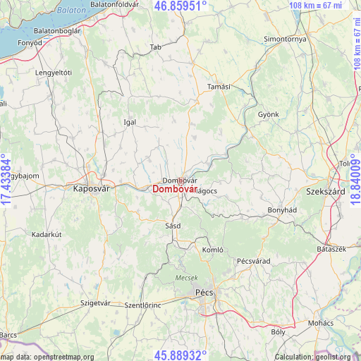
Dombóvár GPS coordinates[2]
46° 22' 35.652" North, 18° 8' 13.056" East
| Map corner | latitude | longitude |
|---|---|---|
| Upper-left | 46.85951°, | 17.43384° |
| Center: | 46.37657°, | 18.13696° |
| Lower-right: | 45.88932°, | 18.84009° |
| Map W x H: | 107.9×107.9 km | = 67×67mi |
| max Lat: | 48.46667° ⇑89.5% North |
| Dombóvár: | 46.37657° |
| min Lat: | ⇓10.5% South 45.79108° |
| min Long | Dombóvár | max Long |
| 16.27358° | 18.13696° | 22.68096° |
| W 16%⇐ | ⇒84% E |
Elevation
Elevation of Dombóvár is 131 m = 430 ft, and this is 1.3 m = 4 ft above average elevation for this country.
| Max E: |
444 m = 1457 ft | 35% |
| Dombóvár | 131 m 430 ft | |
| Avg. | 129.7 m = 426 ft | |
Min E: |
71 m = 233 ft | 65% |
See also: Hungary elevation on elevation.city.
Geographical zone
Dombóvár is located in North temperate zone (between Tropic of Cancer and the Arctic Circle). Distance of this North polar circle is 2244.6 km =1394.7 mi to North.| Distance of | km | miles | from Dombóvár |
|---|---|---|---|
| North Pole | 4850.5 | 3014 | to North |
| Arctic Circle | 2244.6 | 1394.7 | to North |
| Tropic Cancer | 2550.7 | 1584.9 | to South |
| Equator | 5156.6 | 3204.2 | to South |


Nearby cities:
15 places around Dombóvár: (largest is in red/bold)
• Döbrököz
9.3 km =5.8 mi,  57°
57°
• Gödre
16.1 km =10 mi,  231°
231°
• Hidas
30.6 km =19 mi,  115°
115°
• Hosszúhetény
28.8 km =17.9 mi,  145°
145°
• Hőgyész
25.4 km =15.8 mi, 58°
• Kaposvár
25.9 km =16.1 mi,  267°
267°
• Komló
22.7 km =14.1 mi, 154°
• Mecseknádasd
30.7 km =19.1 mi, 123°
• Mágocs
7.9 km =4.9 mi,  111°
111°
• Nagymányok
26.7 km =16.6 mi, 113°
• Szakcs
18.2 km =11.3 mi,  353°
353°
• Szászvár
21.4 km =13.3 mi, 121°
• Sásd
13.7 km =8.5 mi,  189°
189°
• Tamási
30.7 km =19.1 mi,  21°
21°
• Taszár
17.7 km =11 mi, 269°
Sources, notices
• [Note1] Compared only with cities in Hungary existing in our database
• [Src1] Map data: © OpenStreetMap contributors (CC-BY-SA)
• [Src2] Other city data from geonames.org with taken over terms of usage.
• [Src3] Geographical zone / Annual Mean Temperature by Robert A. Rohde @ Wikipedia
