Bonyhád geodata
Bonyhád (Tolna) is a populated place; located in Hungary in Europe/Budapest (GMT+2) time zone. With population of 14,184 people, there are 117 cities with bigger population in this country. Compared to other cities in Hungary, 92.1% of cities are located further ↑North; 76.3% of cities are located further →East and 56.3% of cities have lower elevation than Bonyhád. Note1


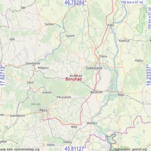
Bonyhád GPS coordinates[2]
46° 17' 57.156" North, 18° 31' 48.864" East
| Map corner | latitude | longitude |
|---|---|---|
| Upper-left | 46.78284°, | 17.82712° |
| Center: | 46.29921°, | 18.53024° |
| Lower-right: | 45.81127°, | 19.23337° |
| Map W x H: | 108×108 km | = 67.1×67.1mi |
| max Lat: | 48.46667° ⇑92.1% North |
| Bonyhád: | 46.29921° |
| min Lat: | ⇓7.9% South 45.79108° |
| min Long | Bonyhád | max Long |
| 16.27358° | 18.53024° | 22.68096° |
| W 23.7%⇐ | ⇒76.3% E |
Elevation
Elevation of Bonyhád is 122 m = 400 ft, and this is 7.7 m = 25 ft below average elevation for this country.
| Max E: |
444 m = 1457 ft | 43.7% |
| Avg. | 129.7 m = 426 ft | |
| Bonyhád | 122 m = 400 ft | |
Min E: |
71 m = 233 ft | 56.3% |
See also: Hungary elevation on elevation.city.
Geographical zone
Bonyhád is located in North temperate zone (between Tropic of Cancer and the Arctic Circle). Distance of this North polar circle is 2253.2 km =1400.1 mi to North.| Distance of | km | miles | from Bonyhád |
|---|---|---|---|
| North Pole | 4859.1 | 3019.3 | to North |
| Arctic Circle | 2253.2 | 1400.1 | to North |
| Tropic Cancer | 2542.1 | 1579.6 | to South |
| Equator | 5148 | 3198.8 | to South |


Nearby cities:
15 places around Bonyhád: (largest is in red/bold)
• Bátaszék
18.9 km =11.7 mi,  128°
128°
• Decs
17.7 km =11 mi,  95°
95°
• Hidas
5.4 km =3.4 mi,  209°
209°
• Hosszúhetény
20.4 km =12.7 mi,  222°
222°
• Komló
23.6 km =14.7 mi,  239°
239°
• Mecseknádasd
9.5 km =5.9 mi, 208°
• Mágocs
23.6 km =14.7 mi,  283°
283°
• Nagymányok
6.2 km =3.9 mi,  248°
248°
• Pécsvárad
17.5 km =10.9 mi, 208°
• Szedres
22.8 km =14.2 mi,  30°
30°
• Szekszárd
14.9 km =9.3 mi,  67°
67°
• Szentgálpuszta
11.2 km =7 mi,  41°
41°
• Szászvár
12.1 km =7.5 mi,  258°
258°
• Zomba
12.7 km =7.9 mi,  12°
12°
• Őcsény
17.5 km =10.9 mi,  84°
84°
Sources, notices
• [Note1] Compared only with cities in Hungary existing in our database
• [Src1] Map data: © OpenStreetMap contributors (CC-BY-SA)
• [Src2] Other city data from geonames.org with taken over terms of usage.
• [Src3] Geographical zone / Annual Mean Temperature by Robert A. Rohde @ Wikipedia
